Prakriti Inbound is a Travel Agency that brings you in touch with the World behind the obvious. If travel is about life, freedom and the joy of discovery, then we committed towards making your travel so much more comfortable - by the way of practical suggestions, value additions, and a willingness to make changes that brings you that extra value. With us as your travel partner, you will always get more World per mile. Prakriti: Your World Travel Partner
Our WebsitesFriends
Our WebsitesBookmark

Enter your email address:

Delivered by FeedBurner

Subscribe to updates

Friday, June 26, 2009

Great Barrier Reef

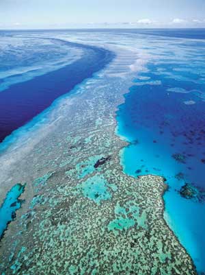
Great Barrier Reef is the world's largest coral reef ecosystem. It is often known as one of the wonders of the world. It is composed of over 2,900 individual reefs and 900 islands scattered for over 3,000 kilometres over an area of approximately 344,400 square kilometers. It consists of 3,000 coral reefs and many islets, atolls and coral cays. The Great Barrier Reef is blessed with the breathtaking beauty of the world's largest coral reef. It supports a wide diversity of life, and was selected as a World Heritage Site. The reef is a very popular tourists spot. Most of the Reef is part of the Great Barrier Reef Marine Park. It was declared as a national park. The Great Barrier Reef has a very rich biodiversity consist of important sea creatures like Whales, Dolphins, porpoises and turtles of more than six different types and also dwarf minke whale, Indo-Pacific humpback dolphin, and the humpback whale, salt water crocodile, sharks, stingrays etc. The Great Barrier Reef is a breeding area for humpback whales and is also the habitat of a few endangered species including the Dugong (Sea Cow) and large Green Sea Turtle.


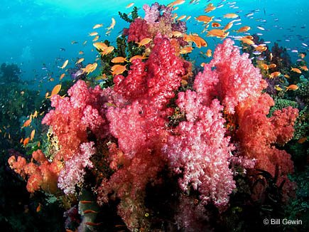
Corals - Great Barrier Reef uniqueness comes from its three thousand coral reefs, islands, cays and lagoons, which are all at different stages of development. The reefs are the product of ten thousands years, during which the oceans rose to their present level after the last Ice Age. Small creatures known as coral polyps join together to form colonies of coral makes the reef. The coral reef can grow only in areas where there are sunlight. The most appropriate environment for coral is shallow warm water where there is a lot of water movement, where the water is salty, low in nutrients and plenty of light. Live coral is coloured by algae, but dead coral is white. Polyp looks like a jelly-like blob surrounded by a ring of tentacles on top. The busiest time in the reef is during night when the coral polyps feed, pushing out their multi-colored tentacles to entrap tiny sea creatures and plants called plankton. The reef looks like full of flowers when the billion of tentacles come out. The coral islands are home to all sorts of sea birds such as frigate birds, gannets, gulls, noddies, sea eagles, shearwaters and terns. Female turtles can be seen laying their eggs here during the summer. The sheer beauty of its fish and coral waterscapes draws two million tourists annually who come to see the underwater spectacle via diving, snorkeling and glass-bottom boating.


Sea Creatures - 17 species of sea snake live on the Great Barrier Reef. More than 1,500 species of fish live on the reef, including the red-throat emperor, red bass, clownfish, and several species of snapper and coral trout. Six species of sea turtles come to the reef to breed – the green sea turtle, hawksbill turtle, loggerhead sea turtle, leatherback sea turtle,olive ridley and the flatback turtle. A large group of dugongs live here. In mangrove and saltmarshes near the reef Salt water crocodiles lived.


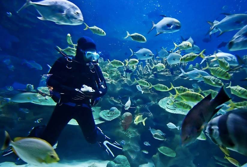
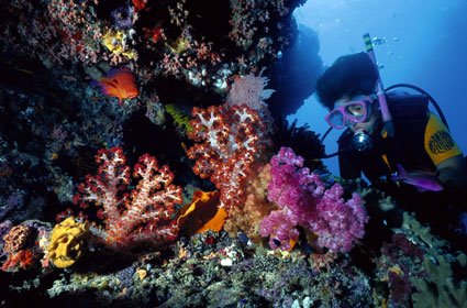
Scuba Diving - This spectacular area has also become one of the top scuba diving sites in the world. There are 16 exclusive dive sites on 4 spectacular outer reefs. These are Thetford, Pellowe, Milln and Flynn. The dive sites have an average depth ranging from approximately 30 to 80 feet. Scuba Diving is most refreshing, entertaining and thrilling. Its tropical climatic conditions makes it popular for Scuba Diving. The sea is calm, throughout the year. Due to which this place has acquired for the activity of scuba diving.

Exploring the Great Barrier Reef is exciting, safe and easy. You can snorkel or scuba dive on boat trips with experienced crew on hand to supervise.Because of its natural beauty, both below and above the water's surface, the Great Barrier Reef has become one of the worlds most sought tourist destinations.

Labels: , , , , ,

Thursday, June 25, 2009

Khajuraho - The Temple City Of Central India

Khajuraho is Located in the Chhatarpur District of Madhya Pradesh.Situated in the Bundelkhand region of Madhya Pradesh, Khajuraho temples are known worldover for its erotic sculptures. The name Khajuraho is derived from the Hindi word 'khajur' meaning date palm. Khajuraho temples were built by the Chandela rulers during the 9th and 10th century AD. Originally there were 85 temples, but now 22 temples are present. Khajuraho temple complex has been divided into three categories namely – Western Group, Southern Group and Eastern Group.The temples Chausath-Yogini, Brahma and Mahadeva made up of granite and others are made up of sandstone, buff, pink or pale yellow in colour.The temple of Vishnu which is now famous as Lakshmana temple built by Yasovarman.The Visvanatha, Parsvanatha and Vaidyanatha temples belong to the time of king Dhanga. King Ganda built Kandariya Mahadeva. Passion,art,lifestyle and culture showcases in the temples of Khajuraho.
Western Group of Temples-The western group of temples is the largest group of temples.It include some of the most famous temples.The western group of temples include Lakshmana Temple, Chausath Yogini, Kandariya Mahadeva Temple, Chitragupta Temple, Matangeswara Temple, Vishwanath Temple, Varaha Temple.

Kandariya Mahadev - It is the most magnificent temple in the western group.It is the largest and dedicated temple to Lord Shiva.The inner portion of the temple is beautifully decorted and the carved ceilings,pillars added beauty to it.The temple built with sandstone. The Kandariya Mahadev temple is divided into ardhamandapa, mandapa, a mahamandapa supported with pillars, the garbagriha.The outer wall shows ,god- goddesses, groups of lovers.
Chausath Yogini – It is the oldest among all and dedicated to Kali.Its name Chausath comes from the 64 Yogini`s of Goddess Kali and one belong to Goddess herself .Today ,only 35 Shrines remain. Chausath Yogini Temple built of granite.
Lakshmana Temple -The Lakshmana Temple is dedicated to the Vaikuntha form of Lord Vishnu.The temple is decorated with various images of gods and goddess in the Hindu Pantheon.It is one of the most preserved temples of khajuraho. The temple is well known for the three-headed idol of the incarnations of Vishnu they are, Narasimha and Varaha.
Chitragupta Temple – It was built between AD 1000-1025.This temple is dedicated to Sun God. It is famous for a Nandi Bull facing the shrine.

Vishwanatha Temple – This temple is dedicated to Lord Shiva and built by King Dhanga. The temple has entrances with magnificent stone lions guarding northern steps and southern steps are guarded by elephants.
Varaha Temple - The Varaha is dedicated to Vishnu's boar incarnation.
Devi Jagdambi Temple – It is decorated with some of the rare sculptures.Uppermost portion of these temples show some of the most erotic sculptures in Khajuraho temples.It is dedicated to Goddess Kali but was originally dedicated to Lord Vishnu.


Matangeswara Temple – The temple is dedicated to Lord shiva.It is outside the premises of Western temple. Matangeswara Temple is famous for 8 feet high lingam.


The Eastern Group
The eastern group of temples divided into two groups Jain temples and Hindu temples.The three Jain temples in the eastern group of Khajuraho temples are Parasvnath temple , the Adinath temple and the Ghantai temple. The three main Hindu temples of the group are the Brahma, the Vamana and the Javari.
Adinath temple – This temple is dedicated to the Jain saint, Adinath.This temple is famous for Carved figures of the Yakshis.
Parsvanath temple – It is the largest jain temple among the eastern group.Carvings are taken from day to day activities.The temple is decorated with beautiful sculptures of celestial beauties.
Ghantai Temple – In this temple you can see a jain goddess on a winged Garuda.Here you can also see carved 16 dreams of the mother of Lord Mahavira.
Brahma temple –This temple is famous for four faced statue of Brahma.
Vamana Temple – The outer walls of this temple shows beautiful carvings of apsaras in different sensuous moods.

Javari temple –This temple is famous for its magnificent architecture and design complex due to which a lot of tourist attracts towards the Javari temple.It is also one of the best Hindu temple in Khajuraho.


Hanuman Temple – Here you could worship 8 feet tall statue of Hanuman.
Dulhadeo temple – The temple dedicated to lord Shiva.Inside the temple there is huge Shiv lingaThe figures carved on the walls are heavy ornamented.The Dulhadeo temple also known as ‘Kunwar Math'.
Chaturbhuj Temple - The exotic sculptor inhances its glamour and elegance of the place.The architecture consist of the mahamandapa and an ardhmandapa, sanctum, shikhara and an antarala.

A combination of science and art of architecture the temples have a very interesting legend behind them that connects them to the origin of Chandela dynasty. The khajuraho temple were built during the reign of the Chandelas who trace their origin to the mythical sage Chandratreya born of the moon. According to the different versions Khajuraho owes its existence from maiden named Hemvati. Hemavati, was a beautiful young daughter of a Brahmin priest and she was a child widow. One day while bathing in the river Rati she was seduced by the moon god. The Moon god, mesmerized by her beauty. A son was born of this union between a human and a god. He was named Chandravarman by his mother. To save herself and her child she took refuge in the dense forest of Central India as she was a child widow. The boy grew up to become a brave king who went on to establish the great Chandela dynasty. When he was established as a ruler, he had a dream-where his mother implored him to build temples that would reveal human passions and thus would bring hidden human desires into open.The temples of Khajuraho attracts tourists towards its erotic sculptures on the temples walls. Though highly sensual and erotic, the engravings on these temples have a symbolic importance and there have been many interpretations of their existence.The motive behind the temple means that if a person wants to achieve God, he has to forget all this at the outset.

The Khajuraho group of monuments has been listed as a UNESCO World Heritage Site. It is one of the top tourist places of India. Khajuraho, the temple city of central India, is famous throughout the world for its exquisitely carved temples. Thousands of visitors and tourists from all over the world visit the Khajuraho temples every year.

Labels: , , ,

Monday, June 22, 2009

Knysna Oyster Festival

Knysna is renowned for its oysters, which are celebrated each year during the Knysna Oyster Festival.The Knysna Oyster Festival attracts around 65,000 visitors each year, among them dozens of food lovers, who come to the festival to slurp their way through platefuls of Crassostrea gigas ,Knysna’s home-grown oyster.They are some of the tastiest on the planet. Oysters taste even better with a glass of wine or bubbly.Oyster festival is all about life ,fun and sports events and also enjoy seafood and wine celebrations.During the festival there are numerous competitions to enter or watch, sport events, including a snowboard competition on a specially set-up snow ramp, and for the little ones include puppet shows, fun workshops. The first Knysna Oyster Festival was held in 1983, on the initiative of a local businessman keen to attract visitors to the Garden Route and one of its favourite resorts in the winter months. The festival is essentially a lifestyle celebration of sport and the good life and has established itself as one of the most popular annual events in the Western Cape.
Soft adventure and sports include bowling,golf,canoeing, navigation event. Some tough competitors can enter the drift dive challenge or the forest marathon while the cycle tour is the biggest mountain and biking event in Southafrica. From Arts & Crafts to Sports, Exhibitions, Fun Fairs, Boat Shows,Food and Wine and other entertainment covered many areas from the Old Goal Maritime Museum to the Belvidere Manor House, Thesen’s Jetty, Lorie Park, Waterfront Knysna Quays, the Heads and other locations along the picturesque beauty scenery of Knysna. More than 80 exciting events ranging from super-popular sports events and adventure challenges to wine and whisky tasting and gala evenings, draw a large crowd to the beautiful Garden Route town. Whether you're sporty , pleasure seeker, adventurous or just plain hungry, Knysna is the place to be in July. Party goers should check out Rockspots, various live music gigs and a variety of entertainment on every day of the festival in July.

Labels: , ,

Friday, June 19, 2009

Jingdong Grand Cnyon

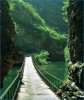
Jingdong Canyon scenic area, located north of Yuzishan Village, is composed of two scenic areas ?? the grand canyon and Jingtai Mountain. The scenic area is adjacent to Panshan Mountain in the south, and to the Jingdong Cave, Jinhai Lake, Huangyaguan
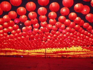
 Great Wall, the Eastern Tombs of the Qing Dynasty and Wuling Mountain in the east, and is about 82 kilometers from downtown Beijing. Since its opening in 1992, many visitors have flocked to the area and it is a well-known scenic area in Beijing and Tianjin.The canyon, about three kilometers long, boasts of dozens of natural sceneries and landscapes, such as green mountain and crystal water, caves and ponds, waterfalls and springs. Jingdong Grand Canyon is situated about 85 kilometers east of the center of Beijing. From an aerial view the canyon, thanks to its many water surfaces, looks like a glittering gem inlaid within the triangle formed by the three big cities of Beijing, Tianjing, and Tangshan. To the south of the canyon lies Panshan Mountain, while to the east lies Huangyaguan Great Wall, Duyue Temple, the Imperial Tombs of the Ming (CE 1368-1644) & Qing (CE 1644-1911) Dynasties, and Wuling Mountains, to name the most noteworthy sites. The best season to explore this vast natural wonder is in early autumn, in August or September.
Also called Wulongtan ("Deep Pool of Five Dragons") Grand Canyon, Jingdong Grand Canyon spans some 6 square kilometers. Inside the canyon are numerous caves, deep pools, craggy peaks, splashing waterfalls, and an enormous reservoir. Hundreds of hectares of pine trees grow in the canyon. Nestled here and there under the verdant pines are small villas and log cabins where visitors to the canyon can pause for a rest. The reservoir's 30-meter-high dam provides deep water for those fond of water sports.

In the sunny spring time, flowers are everywhere on the mountains; in summer, all mountains become green, mountain springs gush and flow, and visitors here would feel cool away from the suffocating summer heat; in autumn, all trees on the mountain turn red and golden, and visitors have the chance to harvest ripe fruits; and in winter, the mountains are covered with snow and ice, and the waterfalls become icy, producing a polar scenery.The scenic area has more than 60 tourist attractions. It has two special scenic areas ?? the Jingtaishan Forest Scenic Area and the Canyon Scenic Area. At the bottom of the canyon, there are five deep ponds connected by brooks, six tourist function zones namely canyon expedition zone, mountain-top sightseeing zone, water amusement zone, exhibition zone, fruit-picking zone and the leisure .

Labels: , , , , ,

Gold Reef City

Gold Reef City is a place of pleasure in Joburg.Gold Reef City is a combination of entertainment complex made up of a theme park and casino facilities. Gold Reef City is a combination of fun and fantasy. Located on an old gold mine, the park is themed around the gold rush on the Witwatersrand. Park staff wear period costumes of the 1880s.The buildings built inside the compound designed like the same period.


The Apartheid museum is located next to Gold Reef City, which is a good place to spend to find out more about the apartheid era.The museum exhibits include antique clothing and children's toys, which take the visitor back 100 years to the city that was.The carefully-documented history of Apartheid,beautifully depicted in the Museum, is a must-see on a South African visit. And nowhere else will the tourist find such a comprehensive and colourful depiction of mining life at the turn of the nineteenth century.
The Theme park has an abundance of adventures rides, gaming, restaurants, and tours for you to enjoy. Its a fun place to take the kids. Youngs as well as old enjoy the adventure rides. From the skyline, the Giant Wheel, Anaconda and Tower of Terror will beckon all you find here. The Anaconda is the only inverted roller coaster in the world and is currently the record holder for the fastest and tallest inverted roller coaster in Africa. The Tower of Terror is a vertical drop roller coaster which features a drop of 47 meters, and a pull-out which features a positive G-Force of a massive 6.3G's.
You can also visit the original gold mine in a lift that goes down to 220 meters below the surface.Those interested in gold mining can see the gold-containing ore veins in an old mine, or observe in a small museum how real gold is poured into barrels.Thousands of feet down to a shaft of the Crown Mines there were round the looooong tunnels and the mine workers demonstrated how the gold was mined which gave a vivid impression of the work of the gold-miners.


The casino at Gold Reef City offers abundance of gaming choices. The casino at Gold Reef City is open 24 hours a day. Your gaming options include slots, various tables, for the high rollers and much more. Everyone from international travellers to family groups will find here something to keep them occupied. With 1600 slot machines and 50 tables ranging from Blackjack, Roulette, Baccarat and various different kinds of Poker, there is an abundance of entertainment.
Gold Reef City provides educational aspect to any visit. The combination of Apartheid museum, historical theme park, rides, restuarants and casino is a superb combination.International travellers savour the offering of traditional African music, dance and history found throughout the complex. It is well worth a visit to Gold Reef City, to see how this entertainment package is put together and presented.

Labels: , , ,

Thursday, June 18, 2009

Lantern Festival

The Lantern Festival (also called Yuanxiao Festival) is on the 15th day of the first Chinese lunar month. It is closely related to Spring Festival.In the old days, people began preparing for the Spring Festival about 20 days before. However, the Lantern Festival,everything returns to normal. Yuan literally means first, while Xiao refers to night. yuanxiao is the first time when we see the full moon in the new year. It is traditionally a time for family reunion.
There are many different beliefs about the origin of the Lantern Festival. But one thing for sure is that it had something to do with religious worship.One legend tells us that it was a time to worship Taiyi, the God of Heaven in ancient times. The belief was that the God of Heaven controlled the destiny of the human world. He had sixteen dragons at his beck and call and he decided when to inflict drought,storms, farmine or pestilence upon human beings. Beginning with Qinshihuang, the first emperor to unite the country, all subsequent emperors ordered splendid ceremonies each year. The emperor would ask Taiyi to bring favorable weather and good health to him and his people. Emperor Wudi of the Han Dynasty directed special attention to this event. In 104 BC,he proclaimed it one of the most important celebrations and the ceremony would last throughout the night.

Another legend associates the Lantern Festival with Taoism. Tianguan is the Taoist god responsible for good fortune. His birthday falls on the 15th day of the first lunar month. It is said that Tianguan likes all types of entertainment. So followers prepare various kinds of activities during which they pray for good fortune.

The third story about the origin of the festival goes like this. Buddhism first entered China during the reign of Emperor Mingdi of the Eastern Han Dynasty. That was in the first century. However, it did not exert any great influence among the Chinese people. One day, Emperor Mingdi had a dream about a gold man in his palace. At the very moment when he was about to ask the mysterious figure who he was, the gold man suddenly rose to the sky and disappeared in the west. The next day, Emperor Mingdi sent a scholar to India on a pilgrimage to locate Buddhist scriptures. After joumeying thousands of miles,the scholar finally returned with the scriptures. Emperor Mingdi ordered that a temple be built to house a statue of Buddha and serve as a repository for the scriptures. Followers believe that the power of Buddha can dispel darkness.So Emperor Mingdi ordered his subjects to display lighted lanterns during what was to become the Lantern Festival.The custom of lighting lanterns continued. However, the lanterns would develop from small simple ones to those of various color and shape. The scale of the celebration would also increase greatly.


Until the Sui Dynasty in the sixth century, Emperor Yangdi invited envoys from other countries to China to see the colorful lighted lanterns and enjoy the gala performances.By the beginning of the Tang Dynasty in the seventh century, the lantern displays would last three days. The emperor also lifted the curfew, allowing the people to enjoy the festive lanterns day and night. It is not difficult to find Chinese poems which describe this happy scene.In the Song Dynasty, the festival was celebrated for five days and the activities began to spread to many of the big cities in China.Colorful glass and even jade were used to make lanterns, with figures from folk tales painted on the lanterns.However, the largest Lantern Festival celebration took place in the early part of the 15th century. The festivities continued for ten days. Emperor Chengzu had the downtown area set aside as a center for displaying the lanterns. Even today,there is a place in Beijing called Dengshikou.In Chinese,Deng means lantern and Shi is market.The area became a market where lanterns were sold during the day.In the evening, the local people would go there to see the beautiful lighted lanterns on display.


Today, the displaying of lanterns is still a big event on the 15th day of the first lunar month throughout China. People enjoy the brightly lit night. Chengdu in Southwest China's Sichuan Province, for example, holds a lantern fair each year in the Cultural Park. During the Lantern Festival,the park is literally an ocean of lanterns! Many new designs attract countless visitors. The most eye-catching lantern is th

Dragon Pole, This is a lantern in the shape of a golden dragon, spiraling up a 27-meter -high pole, spewing fireworks from its mouth. It is quite an impressive sight!Besides entertainment and beautiful lanterns, another important part of the Lantern Festival,or Yuanxiao Festival is eating small dumpling balls made of glutinous rice flour. We call these balls Yuanxiao. Obviously, they get the name from the festival itself. It is said that the custom of eating Yuanxiao originated during the Eastern Jin Dynasty in the fourth centuty, then became popular during the Tang and Song periods.The fillings inside the dumplings or Yuanxiao are either sweet or salty. Sweet fillings are made of sugar, Walnuts, sesame, osmanthus flowers, rose petals, sweetened tangerine peel, bean paste, or jujube paste. A single ingredient or any combination can be used as the filling . The salty variety is filled with minced meat, vegetables or a mixture.The way to make Yuanxiao also varies between northern and southern China. The usual method followed in southern provinceds is to shape the dough of rice flour into balls, make a hole, insert the filling, then close the hole and smooth out the dumpling by rolling it between your hands.In North China,sweeet or nonmeat stuffing is the usual ingredient. The fillings are pressed into hardened cores, dipped lightly in water and rolled in a flat basket containing dry glutinous rice flour. A layer of the flour sticks to the filling, which is then again dipped in water and rolled a second time in the rice flour. And so it goes, like rolling a snowball, until the dumpling is the desired size.The custom of eating Yuanxiao dumplings remains. This tradition encourages both old and new stores to promote their Yuanxiao products. They all try their best to improve the taste and quality of the dumplings to attract more customers.

China Festivals...

Labels: , , , ,

Wednesday, June 17, 2009

Adventure Tour to South Africa

South Africa is surrounded side by side by breathtaking mountains. South Africa offers world-class climbing, surfing, diving, hiking, horseback safaris, mountain biking, river rafting etc. There are over a hundred listed paragliding or hang gliding launch sites were you can enjoy.Thousands of kilometres of hiking trails around the country in desert, forest,you can see. South Africa is the most scenic and beautiful place for tourists to participate in adventure activities.South Africa offers a large variety of adventure activities,sports etc.On the border of the Eastern and Western Cape has the highest commercial bungee jump in the world. South Africa is home of the highest bungi jump, biggest sand dunes and tallest mountain.
Some of the famous adventure activities are :-
Abseiling table mountain - The world famous Table Mountain soars above Cape Town at 1000 metres above sea level. The "long drop" is 112m high - and about a kilometre above the city - making it the world's highest commercial abseil. The views from here are breathtaking.


Bungee jumping - The highest commercial Bungy Jump in the world stands at 216m high and is at the Bloukrans Bridge up the Garden Route of South Africa.


Canoeing, rafting & kayaking - The most popular is the Orange,it's a long, green-fringed oasis running through the mountainous desert area. Incredibly scenic, it also has a few fun rapids.The trail of approximately 75km is suitable for the complete novice and specially designed, stable, 2-man, Indian-type canoes makes it safe for the whole family, both young and old. There is some fun canoeing in the lakes area of the Garden Route, especially Wilderness and Knysna Lagoon.
Fishing - Shore angling is the most popular form of fishing - perhaps because it is the most accessible.
Horseback safaris – If you're comfortable on a horse you can take a ride through magnificent mountain scenery and also through vineyards.
Kloofing - Jumps range from 3 meters high to 22 meters high and it might seem crazy but it will give you an xtreme adventure xperience.
Rock climbing - South Africa offers some of the best, and most diverse, rock climbing in the world. Outside Durban, there are also a lot of sport climbs. The Cedarberg, two-and-a-half hours drive north of Cape Town, is a world-class bouldering area - and boasts some of the best rock climbing routes in the country.Cape Town is built around Table Mountain, a national park consisting of two great, hard rock types - Table Mountain sandstone, and Cape granite, which offers fantastic friction climbing.
Scuba diving - South Africa has an enormously long coastline, which isn't quite within the usual range for tropical diving. Mozambique Current flows down our east coast and at Sodwana Bay we have the most southerly coral reefs in the world.You can see pretty colourful fish and some great nudibranchs, including the outrageous Spanish dancer. Whale sharks, turtles, dolphins and ragged tooth sharks are often seen in specific areas.
Whale Watching - During the correct seasons, Southern Right Whales make the coastline their home and often come here to give birth. Hermanus, a beautiful fishing village up the coast from Cape Town, is a destination for some of the world's best land based and boat whale watching.

Labels: , , ,

Tuesday, June 16, 2009

Kruger National Park

Kruger National Park is Africa's oldest established wildlife park.Kruger National Park covers 18,989 square km and extends 350 km from north to south and 60 km from east to west.It is situated north of Johannesburg.Kruger National Park atmosphere is so unique. Most of the park is situated in the Lowveld. To the west and south of the Kruger National Park are the two South African provinces of Limpopo and Mpumalanga.In the north is Zimbabwe, and to the east is Mozambique. It is now part of the Great Limpopo Transfrontier Park, that links Kruger National Park with the Gonarezhou National Park in Zimbabwe, and with the Limpopo National Park in Mozambique. It is the largest game reserve in South Africa.The park boasts a fabulous variety of game and birdlife in its various habitats.The Kruger National Park is home to number of species: 336 trees, 49 fish, 34 amphibians, 114 reptiles, 507 birds and 147 mammals. The park has 8 main gates that allow entrance to the different camps.The names of these gates are Paul Kruger, Numbi, Malelane, Punda Maria, Crocodile Bridge, Orpen,Phalaborwa , Phabeni and Pafuri.The Kruger National Park is divided into six ecosystems - baobab sandveld, Lebombo knobthorn-marula bushveld, mixed acacia thicket, combretun-silver clusterleaf, woodland on granite, and riverine forest. It boasts the highest variety of wildlife in Africa which inlcudes the "Big Five", hippos, crocodiles, giraffe, cheetah etc.Kruger National Park is divided into 4 regions so visitors could understand easily which region they want to explore first.The regions are :-
The central region :- The central region supports nearly half the park’s lion population as well as numbers of leopard,hyena and cheetah. Possibly the main reason for this is the quantity of sweet grasses and abundant browsing trees found in this area that support a large group of antelope, giraffe, buffalo, zebra and wildebeest.
The northern region :- The Letaba and Olifants rivers contain as much as 60% of the Kruger park’s hippo population, and bird life here abounds. There are plenty of bushpig in the undergrowth of the Luvuvhu River and on most of the river banks you can hope to see sizeable herds of elephant buffalo,bushbuck,and Kudu concentrated near a water supply.
The far north region :-This is a rather fascinating part of the Kruger National Park. Sightings of rare birdlife and major areas of sand formed by river flood plains, combined with sandstone formations of the Mozambique coastal plain, make it attractive to visitors. A picnic site on the river bank provides hours of splendid bird viewing.
The southern region :- The valleys are home to trees rarely found in other parts of the Kruger park, such as the Cape chestnut, coral tree and lavender fever-berry; and granite lies beneath most of the region, producing distinctive smoothed koppies at irregular intervals, which are typically surrounded by rock figs and form ideal locations for rock dassies or hyrax, baboon and klipspringer, not to mention the odd leopard. This is the region where you’re almost sure of seeing a white rhino as most of them occur here.
Safari tours :- You can also enjoy Safari tours.Hence the Kruger National Park is one of South Africa`s premier tourist attractions. Safari tours are mostly common here.During safari you can view Big Five,Elephant,Lion,Rhino,Buffalo and Leopard.You should also see Zebras, Wildebeest,Bush pig,Impala,Giraffes and baboons which are all quite easily spotted. The best time to see game in the Kruger National Park is during the winter months of April to September.November and December are the calving months, this is a fantastic time for a safari.
Water and Bush Birds in the Kruger :- There are over 600 species of water and bush birds in South Africa’s top reserve.Great egrets, reed cormorants and white-faced ducks are found by the water alongside giant kingfishers, grey and green-backed herons,plovers and black-winged stilts.You can spoteasily hornbills as well as eagles, hooded vultures and other birds of prey. Among the most colourful birds are Carmine bee eaters and lilac-breasted rollers.
Bush walks :- It is one of the most incredible ways to learn about the fragility of the ecosystems of the Kruger Park and to see the smaller, animals and insects of the park like termites, spiders, snakes and plants. Bush walks can last up to four hours.
Wilderness trails :- There are many trails offer in the Kruger National Park.Some of them are Metsi-Metsi, Napi, Massingir and the Sweni Wilderness.

Labels: , , ,

Dian Chi Lake

Kunming is famous for its multitudinous scenic spots and places of interests from ancient times, while the West Mountain & the Dian Chi Lake are the outstanding places among them. They are located in the southwest of Kunming in Yunnan Province. The West Mountain is 15 km away from Kunming, standing straight in the lakeside of the Dian Chi Lake and on the foot of the mountain is just the Dian Chi Lake.

The Dian Chi Lake, also called "Kunming Lake", "Kunming Pond", and "Southern Lake of Yunnan" in ancient times, is a plateau lake with beautiful scenery, the lake is 40 by 8 kilometers and is 1,886 meters above sea level. The lake water and the sky seem joining mutually like a city sea, dense mist and rolling water are on the surface of the lake, and sails are strolling above the water. It claims to be "a pearl on the Yungui Plateau" for a long time.Being the largest lake in Kunming and the sixth largest fresh water lake in China, Dian Chi Lake is 300 square kilometers (116 square miles) in surface area, 1,885 meters (6,185 feet) in altitude and about 40 kilometers (25 miles) in length (from north to south).The west side of Dian Chi Lake is the mountain forest, while on the east side are lands dotted with the fisheries and agribusinesses. Traditional fishing boats still sail on the lake, hooking and netting. Taking a boat to voyage between the blue sky and the green water, breathing the fresh air and viewing the birds flying just at your side, what an enjoyable, light-hearted and free moment it is!.When the weather is fine, there are white flocculent or massive clouds floating in the cerulean sky, the cyan water waves under the golden sunshine and the surrounding mountains reflect their silhouettes on the water. If you take a walk on the lake shore you will feel intoxicated by the beautiful landscape.The most beautiful view of Dian Chi Lake appears at dawn and sunset, the refraction of the ethereal rays glitter on the water surface just like thousands of silver fishes swimming and playing. At night, when the breeze is fleeting over the water and the world is brimming over with hazy moonlight, Dian Chi Lake lies in silence and breathes in peace like a sleeping beauty.The ocean-like Dian Chi Lake is the best place to go for those people who wish to get away from the bustling city and be close to the nature. Facing such a beautiful and capacious place, one may forget everything even himself, the only thing left is the amazing scenery before you.On the West Mountain, you can overlook the crossed green fields and the vast green Dian Chi Lake, the high and low peaks ranged at random at distance and emerald forests and elegant meditation rooms closely.Having the advantages of beautiful scenery and rich plants on the mountain, the West Mountain has already become a large-scale forest park after the transformation by Kunming City Government. Nearly 3,000 kinds of woody plants are growing on the mountain and the Ginkgo, Yulan magnolia and epiphyllum are unique in Kunming. The sago cycas, metasequoia, yew podocarpus and peacock China fir handed over in the geology history and the rare plants in the Dianzhong Plateau such as moss, alangium and Yunnan camphor tree are in addition to the above.The Longmen is the most beautiful scenic spot on the West Mountain. If climbing the Longmen and overlooking the endless Dian Chi Lake, you will see the green wave ripples and the pretty scenes of the lake. If enjoying the Dian Chi Lake on the close Grand View Pavilion, you will see that the waving water is running to your eyes and the sails are strolling in the light mist on the lake.
Yunnan Ethnic Villages:
The village acts as a good shortcut to understand the social customs of the ethnic groups in Yunnan. It has a natural sun-bathing area where you can escape from the heat of summer. Twenty-five ethnic nationalities have their respective villages and conduct many activities to present their unique folkways and beautiful clothes. Also you can enjoy the water screen movie and an elephant performance, have a taste of the local dishes and buy pretty handicrafts.
Daguan Park:
Daguan Park is vibrant with rock gardens, pavilions, bridges and murmuring water. It is famous for the longest couplets in China on the Daguan Pavilion. The Daguan Pavilion was built in the year 1828. It commands a lovely view. The couplet written in the Qing Dynasty (1644-1911), contains 180 characters brimming with literary grace. During festival evenings, gatherings take place here.

Baiyukou Park:
Baiyukou Park is on the west bank of Dianchi Lake. Here a small hill looks like a white fish opening its mouth to Dianchi Lake. Near the Irregular shore line, beautiful gardens are hidden among green trees. In spring, the cherry trees are in blossom, adding luster to this serene place. Overlooking Dianchi Lake, you can see white sails of boats on the glistening lake and gulls skimming over the waves.

Haigeng Bank:
Haigeng Bank is about four kilometers (2.5 miles) long while ranging in width from forty meters (131 feet) to three hundred meters (984 feet). The bank, like a floating jade belt, is in fact a watershed of the Dianchi Lake. Slender willow twigs sweep the lake in the gentle breeze. In the south is a wonderful natural swimming pool which is always crammed with people in midsummer.
Kwan-yin Hill:
Kwan-yin Hill is bordered by the vast lake and has an altitude of 2,040 meters (6,693 feet). Lofty peaks on this hill seem to thrust themselves straight towards the sky. A Kwan-yin Temple built here in the Ming Dynasty (1368-1644) was once a popular resort of Buddhism. Remaining are a seven-tier brick pagoda, houses, and a gate to the Kwan-yin Temple.

Labels: , , , ,

Spring Festival

The Spring Festival is the largest and most important festival in China. It is the first day of the lunar calendar and usually occurs somewhere between January 30 and February 20, heralding the beginning of spring, thus it is known as Spring Festival. This traditional festival is also a festival of reunion; no matter how far away people are from their homes, they will try their best to get back to have the Reunion Dinner.

The Chinese meaning of this festival is Guo Nian. Guo means "pass over" and Nian means "year." The origin of the Chinese New Year Festival can be traced back thousands of years through a continually evolving series of colorful legends and traditions. According to one of the most famous legends, in ancient China there lived a horned monster named Nian who was extremely ferocious. Nian lived deep at the bottom of the sea all the year round and climbed up to the shore only on New Year's Eve to devour the cattle and kill people.Thereupon on the day of every New Year's Eve people from all villages would flee, bringing along the old and the young, to the remote mountains so as to avoid the calamity caused by the monster Nian. Then, one New Year's Eve, the people of Peach Blossom village were getting ready to hide when there came from outside the village an old beggar with a stick in his hand and a bag hanging upon his arm. His eyes twinkled like stars and his beard was silver.Seized with panic, the villagers were in a great hurry to run away. Some were closing the windows and locking the doors, some were packing, and others were urging the cattle and driving the sheep. At a time when the people were shouting and the horses were neighing no one was in the mood to care for the beggar.Only a grandmother living in the east end of the village gave the old man some food and advised him to flee to the mountains to avoid the monster. But the old man stroked his beard and said with a smile, "If you allow me to stay at your home for the night, I'm sure to drive away the monster Nian.The old woman was surprised to hear this. She looked at him unbelievingly only to find that, with white hair and ruddy complexion, the old man had a bearing out of the ordinary. She went on to persuade him to take flight. But he only smiled without reply. Thereupon the grandmother could not help but leave her home and flee to the mountains.Around midnight the monster Nian rushed into the villages. He found the atmosphere was quite different from that of the previous year. The house of the grandmother in the east end of the village was brilliantly illuminated, with bright red paper stuck on the doors. Greatly shocked, the monster gave a strange loud cry.The monster Nian stared angrily at the house for a moment then, howling furiously, made a charge at it. As he approached the door, there suddenly came the sounds of explosions. Trembling all over, the monster dared not take a step forward.It turned out that the color red, flames, and explosions were what Nian feared the most. And when the door of the grandmother's house was thrown open and an old man in a red robe burst out laughing in the courtyard, the monster Nian was scared out of his wits and fled helter-skelter.The next day was the 1st of the first lunar month. When people came back from their hideouts and found everything safe and sound, they were quite surprised. The old woman suddenly realized what had happened and told the villagers about the old beggar's promise.The villagers swarmed into the grandmother's house, only to find that the doors were covered with red paper, the embers from a pile of bamboo were still giving out exploding sounds in the courtyard, and a few candles were still glowing in the room.The story was soon spread far and wide and everybody was talking about it. They concluded in the end that the old beggar was surely the celestial being who came to expel the calamities and bless the people, and that red paper, red cloth, red candles, and the exploding firecracker were certainly the magic weapons to drive out the monster Nian.To celebrate the arrival of such good luck, the elated villagers put on their clothes and new hats and went one after another to their relatives and friends to send their regards and congratulations. This was soon spread to the surrounding villages, and people all got to know the way to drive away the monster Nian.

From then on, on each New Year's Eve, each family sticks on their doors antithetical couplets written on red paper, blows up firecrackers, keeps their houses brilliantly illuminated and stays up late into the night. Early in the morning of the 1st of the first lunar month they go to their relatives and friends' homes to send their regards and congratulations. These customs have been passed down through the generations, making it the most ceremonious traditional festival of the Chinese people.Spring Festival which is also called Chinese New Year falls on January, 1st, according to the Chinese lunar calendar. It is usually called as Yinlinian. This is the most important festival in China. It originated in Shang DynastyWhen Spring Festival comes, spring comes as well. Everything comes to life and plants are prosperous. Just having experienced a cold winter, people are so excited to welcome a new spring.The warm atmosphere is not only in the houses, but also in the streets. In many places, lion dances and dragon lantern show are performed during Spring Festival. In some places, people kept the customs of Shehuo performance, visiting flower market, going to the temple fair. During this period, the cities are full of lanterns and the streets are crowded with people. Activities last to the 15th of January, this can be an end of Spring Festival.People in different places celebrate Spring Festival in different ways. Generally speaking, a Chinese family will hold a Spring Festival feast, light firecracker and give lucky money to children during Spring Festival. See details of Chinese New Year Celebration (Spring Festival).

More China festivals...

Labels: , , ,

Monday, June 15, 2009

Jiuzhaigou Valley

Jiuzhaigou Valley is one of the most beautiful National Parks in the world, and definitely the number one National Park in China. If you like Alpine landscapes, streams and waterfalls you should not miss the Jiuzhaigou Valley. Currently this is one of China's top tourist destinations among Chinese visitors, but it is still not very well-known among foreigners. If you have already visited China's main tourist cities, and want to see an amazing natural environment, you should add Jiuzhaigou Valley to your destinations list.

It is said that if there should be wonderlands on the earth, Jiuzhaigou Valley must be one of them. There is no equal elsewhere that has sceneries and fables of dreamlike eloquence, or natural purities like a fairyland as Jiuzhaigou Valley.Jiuzhaigou Valley is located in Nanping County, 450 kilometers (about 280 miles) to the north of Chengdu City. Its name is due to the existence of nine stockaded villages of Tibetan origin, and it is always regarded as a holy mountain and watercourse by the Tibetan people.Jiuzhaigou Valley is a great masterpiece of nature having dreamlike scenery and abundant natural resources. It combines blue lakes, waterfalls, verdant forests, snow-covered mountains, and the folk customs of the Tibetan and Qiang peoples.


Legend has it; that long, long ago the deity of mountain named Dago had a crush on the goddess Semo, and he gave a mirror that was made from wind and cloud to the goddess. However, the devil appeared and made trouble to Semo. Inadvertently, Semo broke the mirror into 108 pieces, which fell down to the earth and then turned to 108 colorful lakes. The lake is also called Haizi by local people.

Shuzheng Valley:
Shuzheng Valley is a main tourist route of Jiuzhaigou Valley. It is about 14 kilometers (about nine miles) in length with over 40 lakes, representing 40% of all the lakes in Jiuzhaigou. The major scenic spots in Shuzheng Valley are Double-Dragon Lake, Bonsai Beach, Reed Lake, Spark Lake, Tiger Lake, Shuzheng Waterfall, Rhinoceros Lake, and Nuorilang Waterfall, etc.


Shuzheng Waterfall:
Shuzheng Waterfall is the first waterfall you will encounter in the valley. It is 62 meters (about 203 feet) wide and 15 meters (about 49 feet) tall. Though it is the smallest of the four main waterfalls in Jiuzhaigou Valley, it will bring heart quakes to first time visitors. The green forests surround nineteen lakes of different sizes and levels. The lake water in the upper reaches flows slowly along the shoal and is divided into countless streams by the groves in the lake. Then the streams join on the top of Shuzheng Waterfall and suddenly drop down to the lower lakes. The sprays fly in the air, creating an elegant screen.

Nuorilang Waterfall:
Nuorilang Waterfall is 32 meters (about 105 feet) wide and 25 meters (about 82 feet) tall, and it is the widest waterfall in Jiuzhaigou Valley. Nuorilang means 'grand and magnificent' in Tibetan, so it is a gorgeous waterfall. The top of the waterfall is very flat. It is said that originally there was no waterfall but a platform here long ago. Then a monk brought a spinning wheel when he returned to this place. A Tibetan girl learnt the skill of spinning very soon, so she carried the wheel to the platform and showed her sisters how to spin. The cruel man Roza considered that she was doing something evil and kicked her, as well as the spinning wheel off the cliff. In no time, torrents rushed Roza and his accomplices down the mountain, so the platform had turned into the waterfall. When the sun shines in the morning, flowery rainbows can be seen in the sky, which make the waterfall more charming and splendid.


Peacock River:
Peacock River is 310 meters (about 1,017 feet) in length and wends along the deep valley with flowers and trees on its two sides. The water appears in a cacophony of varietous colors: dark green, golden, and sapphire blue. When autumn comes, the forests are covered with hoarfrosts and the fallen leaves are bestrewed all over the lake. When seen from above, the bright and clear water flows in a colorful world and it is like a peacock displaying its fine tail feathers.


Five-Flower Lake (Wuhua Lake):
The pride of Jiuzhaigou Valley, Five-Flower Lake lies at the end of the upper reach of Peacock River, 2,472 meters (about 8,110 feet) above the sea level and five meters (about 16 feet) in depth. Most of the colorful leaves are gathered in the lakefront and interlaced as brocades. The water that contains calcium carbonate as well as hydrophytes with different colors presents a versicolor sight, azure blue, blackish green and light yellow, etc, so it is named Five-Flower Lake. The local people say that it is a holy lake, and where there is the water, there must be flourishing flowers and trees. When looking down from the mountain, you will find that the lake with hills on three sides is just like a huge upended cucurbit pouring colorful water to the lower place.

More China attractions...

Labels: , , ,

THE RHINO LAND: KAZIRANGA NATIONAL PARK

One of the main reasons to visit Assam was to see the mighty river Brahmaputra and to site the one horned Rhino at the Kaziranga national Park.A picturesque drive from the commercial capital of Guwahati of nearly 220 kms (approximately 5 hours) brings you to the natural habitat of the one-horned Rhinocerous, the Kaziranga Park, which is one of the best places of the world to see the Great one horned Rhinocerous on the verge of extinction.

Kaziranga lies on the southern banks of the Brahmaputra River, northeast of the Guwahati, partly in Golaghat district and partly in Nagaon district of the state. The forest full of tall elephant grass and swampy marsh lands, an ideal habitat of the Rhino was originally established as a game reserve and later declared a sanctuary in 1940 to counter excessive poaching. But it was only in 1974 that it was given the status of National Park. Kaziranga has the rare distinction of not only saving the prehistoric mammal from the verge of extinction but also of increasing its population in a spectacular manner. With a population of over a thousand, the one-horned Rhino's are the largest concentration in the subcontinent.

This prehistoric animal has stood the wrath of time and has fought to adjust with changes in nature and its surroundings. It is a nearly hairless mammal with a height of around 6 feet and weighing nearly four tons. Basically a solitary and peace loving animal, the females can get disturbed without any provocation when in custody of its calf. The single horn on the nose, which can sometimes be as long as five feet, is the main instrument of the animal for a fight. The Rhino likes to live in tall grassland and swampy marshes. They are brown or gray in colour and thick skin forms plate like folds resembling armor. The horn if once broken grows again, and it is for this horn, which is believed to have medicinal prowess, that the animal is hunted down.
Watching the magnificent rare specie from the back of an elephant, early on a winter morning, is a sheer delight.Along with the Rhinos the marshland is habitat for the many other species as well like the elephants, Indian Bison, swamp deer and many other species of deer, the sloth bears and tigers too. The jungles and the marshy lands also make a good habitat for the migratory birds like the Pelicans and Hornbill, Egret and eagles as well. The common birds and animals also have a major population in the park. Thus viewing wildlife at Kaziranga Park because of its vast open spaces, the presence of the mighty Brahmaputra, and adjoining Mikir hills makes the trip a complete jungle adventure.Near to Kaziranga are some good excursion points. The Kakochang waterfalls and the ruins of Numaligarh and many tea gardens are prime attractions.

Labels: , , ,

Friday, June 12, 2009

Yellow Mountain: Huangshan

The famous scrolls of
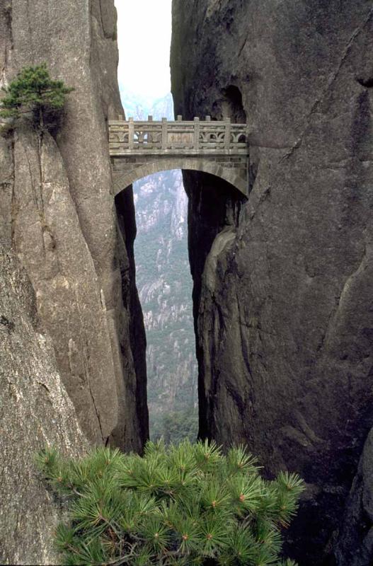
 Chinese black and white paintings of high mountains, rocks, trees and sea of clouds come alive in Huangshan Mountains in the south Anhui province. It is a marvelous mountain area, now on the UNESCO World Cultural and Natural Heritage List. There is an old saying well known throughout the country "No need to see any other mountains after Huangshan!" Huangshan has spectacular landscape with its four unique scenes: interesting shaped rocks, waterfalls, unique shaped pine trees growing out of rocks, and its sea of clouds. Huangshan has all, the steepness, the grace, the elegance, and so on. Huang Shan Mountain area is such a marvelous place with spectacular vista and its ever-changing scenes attract tourists in all seasons and inspire countless Chinese painters and poets for thousands of years.Of all the notable mountains in China, Mount Huangshan, to be found in the south of Anhui province, is probably the most famous. Originally known as Mt. Yishan it was renamed Mt. Huangshan in 747 AD in recognition of the legendary Huang Di, who was the reputed ancestor of the Chinese people and who made magic pills for immortality here.

Wu yue is the collective name given to China's most important mountains, namely Mt. Taishan in Shandong Province, Mt. Huashan in Shaanxi Province, Mt. Hengshan in Shanxi Province, Mt. Songshan in Henan Province and Mt. Hengshan in Hunan Province. It is said that you won't want to visit any other mountains after seeing wu yue but you won't wish to see even wu yue after returning from Mt. Huangshan. This saying may give you some idea of the beauty and uniqueness of Mt. Huangshan. Together with the Yellow River, the Yangtze River and the Great Wall, Mt. Huangshan has become one of the great symbols of China.


Yellow Mountain, also named Huangshan,is famous for its marvelous and beautiful scenery. It is one of the most popular tourist resorts in China.The landform of Yellow Mountain is a kind of typical granite mountains and forests. It was the result of several movements of lithosphere as well as the work of nature during the long geological age. 77 peaks are more than 1,000 metres above sea level. Granite limestone towers and oddly-shaped rocks spread all over the scenic area.

The legendary pines, oddly-shaped rocks, phantasmagoric sea of clouds, hot springs and winter snows have own Yellow Mountain the world famous reputation of the five unique views. Yellow Mountain has brought together all the strong points other mountains have: grand, strange, baffling, arduous, steep, flourishing, quiet and spacious.There is another noticeable place near Yellow Mountain - Huizhou Culture (also known as Xin'an culture) which is one of the three regional cultures in China. Huizhou Culture includes Xin'an Philosophy, Xin'an Painting School, Xin'an Medicine School, Huizhou Style Architecture, Anhui pot gardening, Huizhou Sculpture, Huizhou Opera, Huizhou Cuisine and so on. It's a miracle of excellent traditional culture of the Chinese nation.


More on China...

Labels: , , ,

Drakensberg

The Drakensberg mountains of South Africa is a 200-kilometre-long mountainous wonderland and world heritage site.It is the highest mountain range in Southern Africa.It is also know as “uKhahlamba” or“The Barrier of Spears”. The Dutch Voortrekkers named it as 'The Dragon Mountain'. It forms a natural border between Lesotho and KwaZulu Natal.The largest proportion of the Drakensberg area falls in the province of KwaZulu-Natal. The Drakensberg Range has three sections,South, Central and North.The Northern Drakensberg comprises Royal Natal National Park,Rugged Glen Nature Reserve,Amphitheatre,Mont-aux-Sources, Ifidi, Mnweni & Ntonjelana valleys, Singati Valley, the Mnweni cutback, Mponjwane, and the Saddle.The Central Drakensberg or Berg comprises of Mlambonja Wilderness Area, Cathedral Peak,Organ Pipes, Ndedema Gorge,Ndumeni, Mdedelelo Wilderness Area, Monk’s Cowl, Champagne Castle,Cathkin Peak,Injasuti, and Giant’s Castle Game Reserve.Southern Drakensberg has Mkhomazi Wilderness Area,Loteni,Kamberg,Vergelegen,Hinghmoor,Sani Pass,Mzimkhulwana Nature Reserve, Mzimkhulu Wilderness Area, Garden Castle, Rhino, Giant’s Cup Hiking Trail, Bushman’s Nek, Sehlabathebe National Park, Thomathu, Devil’s Knuckles, and Ramatseliso's Nek.
The mountains are capped by a layer of basalt approximately 1,400 m thick, with sandstone resulting in a combination of steep-sided blocks.The Drakensberg Mountains, with their awe-inspiring basalt cliffs, snowcapped in winter, lush yellowwood forests and cascading waterfalls, form a massive barrier separating KwaZulu-Natal from the Kingdom of Lesotho. This 243,000 hectare mountainous region known the uKhahlamba-Drakensberg Park has been preserved and venerated for eons since the San people or bushmen roamed these slopes.This is one of South Africa`s best hiking spots, with varied environments and awesome views. It is an important region for adventure activities like mountaineering, camping, bird watching, river crossing, trout fishing, and many more such activities.The entire Drakensberg is riddled with incredible waterfalls, rock pools, mountain streams, crisp mountain air, caves and special spaces that draw both visitors to South Africa and locals alike.
Cave and cave paintings :- In Drakensberg of KwaZulu Natal lies Ukhahlamba-Drakensberg Park which is a world heritage site , it also has over 600 examples of rock paintings in caves around the park. The Drakensberg has between 35000 and 40000 works of bushman art and is the largest collection of such work in the world. The oldest painting on a rock shelter wall in the Drakensberg dates back about 2400 years", "paint chips at least a thousand years older have also been found.It is famous for its outstanding both in quality and diversity of subject. Drakensberg range is a major tourist destination in South Africa and one of the best-known adventure destinations in the world.


Mont-aux-Sources :-It is regarded as the one of the highest portions of the Drakensberg Mountain range. Mont-aux-Sources is regularly described as a mountain block. The amphitheatre, of which Mont-aux-Sources is part, is a five kilometre wall of rock that is at once intimidating and awesome, and forms part of the Royal Natal National Park.It is surrounded by mountain peaks and visitors can enjoy hiking.
Cathedral Peak :- It is surrounded by most spectacular mountain scenery.The peak is bordered by two wilderness areas the Mdedeleo and Mlambonja.It is a retreat for nature lovers, mountain bikers and rock climbers.
Giant’s Castle :- It lies at the southern end of the Drakensberg.It get its name from the outline of the peaks and escarpment that combine to resemble the profile of a sleeping giant.There are a number of hikes to choose from and they range from the rather severe hike to Bannerman Hut, to the more sedate Champagne Pools circular walk from Giant’s Castle main gate, which takes you to secluded pools for swimming and fishing.

Some more attractions :-

Labels: , ,

Thursday, June 11, 2009

West Lake (Xi Hu)

Originally a shallow sea inlet, due to the laying down of silt this 5.68 square kilometers (about 1,404 acres) of water became the famous West Lake. With an average depth of just five feet the lake comprises five distinct sections. The largest part is known as the Outer Lake and it is bounded by the North Inner Lake, Yuehu Lake, West Inner Lake and Lesser South Lake. Held in the embrace of hilly peaks on three sides, this water wonderland has been an attraction for centuries and it is small wonder that it was a favourite imperial retreat. The lake and its environs have all the elements of a traditional Chinese garden but on a grand scale. The natural setting of strangely shaped peaks, serene forests and springs, dense foliage and a myriad of blossoms especially in springtime are enhanced by a treasury of sculpture and architectural features. Whatever the season, the panorama is pleasing to the eye and the nuances of light shade together with the moods of the weather present an ever-changing picture that justifiably has been described as 'intoxicating'.
A number of specific features can be singled out as worthy of particular note. To the south of centre of the Outer Lake is a manmade island known as the Island of Little Oceans, that encloses four small lakes. From here one can view the Three Pools Mirroring the Moon when at night candles are lit in stone lanterns jutting out of the water thus creating the impression of the reflections of three moons. The scene is truly magical on the night of the Autumn Moon Festival. Solitary Hill Island lies between the Outer Lake and the north Inner Lake and is an ideal spot from which to admire the vista. The nearby Two Peaks Embracing the Sky is another impressive sight, especially when crossing the lake by boat.
Near to the lake can be found the Ling Yin Temple in its woodland setting near to Fei Lai Feng (Peak Flown From Afar). Legend has it that this limestone peak flew from India where it had formed part of a holy mountain. These are of particular interest to Buddhists and those who have a love of sculpture and art. The Mausoleum of General Yue Fei is a monument to the patriot who was murdered in 1141 at the behest of his archrival Qin Hui, the Song prime minister. These buildings like others in the vicinity of the lake such as the slender Six Harmonies Pagoda add to the calm and beauty of their surroundings.

No visitor to the West Lake and Hangzhou can fail to learn something of this city's most famous products, namely silk and Longjing (Dragon Well) Tea. Since the Tang Dynasty (618-907) silk products from Hangzhou have found their way all over the world. The National Silk Museum is the first Chinese national museum to be dedicated to silk culture and is the largest of its kind in the world. A similar museum is dedicated as homage to tea. Located at the West Lake Dragon Well Tea Plantation, the National Tea Museum provides a fascinating insight into the history and production of Chinese tea. Often referred to as the 'wonders of West Lake' Longjing (Dragon Well) tea and Hupao (Running Tiger) Fountain is each worthy of the attention of the visitor.
Another natural spectacle to be found here is the tidal bore of the Qiantang River that has enthralled people for centuries. Overlooking the river estuary stands the 13 storey high Six Harmonies Pagoda. Dating from 970 and built on the site of an earlier pagoda that served as a lighthouse, the name refers to the six codes of Buddhism i.e. harmony of the body, speech and thought and the renunciation of personal pleasure, opinions and wealth. A climb to the top of the pagoda carries the reward of an impressive view over the river.

Crossing the river is the Qiantang River Bridge. This is the first two-tier bridge to have been designed and built by Chinese engineers in modern times. The other great feat of much earlier engineering is the Grand Canal. Linking Hangzhou in the south with Beijing in the north, this is the longest man-made waterway in China and surpasses both the Suez and Panama canals.

Labels: , , , ,

Suncity

Suncity in South Africa offers everything and more and it has become a haven for holidaymakers to South Africa.Sun City Resort is set in the North West Region of South Africa.Sun City is a luxury South African casino resort. The Resort has a unique heartbeat and an African rhythm of its own. It was planned in the style of a sunken, legendary African town .This is pure fantasy and your every desire is met.It offers a multitude of attractions and activities to keep everyone occupied. Sun City attracts more than 25.000 visitors every day.It has a combination of golf, game and gambling, as well as world class hotels.It is the perfect choice for any holiday in South Africa. A huge variety of sport activities can be enjoyed at Sun City.It is surrounded by the magnificent mountains of South Africa` s Pilanesberg National Park and the game viewing opportunities are superb. Sun City offers the best golfing in Africa.You can enjoy Flying in a Tiger Moth, riding an elephant, hot air ballooning, archery, quad biking and much more. There are four world-class hotels including the magnificent Palace of the Lost City. Suncity in South Africa offers everything and more and it has become a haven for holidaymakers to South Africa .It amazed the visitors with its glamorous casinos, gourmet restaurants, sports facilities etc.You could get a lot of facilities here:-

Watersports and Activities :- South Africa has year round good atmosphere making it famous for sports such as squash, swimming,tennis, horse riding,mountain biking, golf etc. Sun City has laid out spectacular jogging trails. A wide range of water sports including Water-skiing, Parasailing and Sunset Cruises can be enjoyed at the Resort's Waterworld.
Sun City Nightlife and Entertainment :- Here famous artists perform throughout the year.
Valley Of The Waves :- This is the most advanced water park in South Africa. This water park has five exhilarating flume rides.

Labels: , , ,

Potala Palace

Originally built by King Songtsen Gampo in the seventh century, Potala Palace is located on the Red Hill of Lhasa, Tibet. Destroyed by lightning and war, Potala Palace had been rebuilt by the Fifth Dalai Lama in 1645. Since then, Potala Palace has become the seat of Dalai Lamas and also the political center of Tibet. The thirteenth Dalai Lama extended it to the present size, 117 meters (384 ft) in height and 360 meters (1,180 ft) in width, covering an area of more than 130, 000 sq meters (about 32 acres). Mainly comprised by the White Palace (administerial building) and the Red Palace (religious building), Potala Palace is famous for its grand buildings, complicated constructions, devotional atmosphere and splendid artworks.

Perched upon Marpo Ri hill, 130 meters above the Lhasa valley, the Potala Palace rises a further 170 meters and is the greatest monumental structure in all of Tibet. Early legends concerning the rocky hill tell of a sacred cave, considered to be the dwelling place of the Bodhisattva Chenresi (Avilokiteshvara), that was used as a meditation retreat by Emperor Songtsen Gampo in the seventh century AD. In 637 Songtsen Gampo built a palace on the hill. This structure stood until the seventeenth century, when it was incorporated into the foundations of the greater buildings still standing today. Construction of the present palace began in 1645 during the reign of the fifth Dalai Lama and by 1648 the Potrang Karpo, or White Palace, was completed. The Potrang Marpo, or Red Palace, was added between 1690 and 1694; its construction required the labors of more than 7000 workers and 1500 artists and craftsman. In 1922 the 13th Dalai Lama renovated many chapels and assembly halls in the White Palace and added two stories to the Red Palace. The Potala Palace was only slightly damaged during the Tibetan uprising against the invading Chinese in 1959. Unlike most other Tibetan religious structures, it was not sacked by the Red Guards during the 1960s and 1970s, apparently through the personal intervention of Chou En Lai. As a result, all the chapels and their artifacts are very well preserved.

From as early as the eleventh century the palace was called Potala. This name probably derives from Mt. Potala, the mythological mountain abode of the Bodhisattva Chenresi (Avilokiteshvara / Kuan Yin) in southern India. The Emperor Songtsen Gampo had been regarded as an incarnation of Chenresi. Given that he founded the Potala, it seems likely that the hilltop palace of Lhasa took on the name of the Indian sacred mountain. The Potala Palace is an immense structure, its interior space being in excess of 130,000 square meters. Fulfilling numerous functions, the Potala was first and foremost the residence of the Dalai Lama and his large staff. In addition, it was the seat of Tibetan government, where all ceremonies of state were held; it housed a school for religious training of monks and administrators; and it was one of Tibet's major pilgrimage destinations because of the tombs of past Dalai Lamas. Within the White Palace are two small chapels, the Phakpa Lhakhang and the Chogyal Drubphuk; dating from the seventh century, these chapels are the oldest surviving structures on the hill and also the most sacred. The Potala's most venerated statue, the Arya Lokeshvara, is housed inside the Phapka Lhakhang, and it draws thousands of Tibetan pilgrims each day.

Upon entering the East Portal, visitors will come into the Deyang Shar courtyard where Dalai Lamas watched Tibetan opera. West of the courtyard is the White Palace. As the winter palace of Dalai Lamas, the White Palace is a seven-floor building originally built in 1645. The wall of the palace was painted to white to convey peace and quiet. The Great East Hall on the fourth floor is the largest hall in White Palace, occupying a space of 717 sq meters (about 7,718 sq ft). This hall was also the site for holding momentous religious and political events. The living quarters and offices of regents are on the fifth and sixth floors and while the top floor consists of the East Chamber of Sunshine and the West Chamber of Sunshine. Because of the sunshine in the chambers all year round, the East and West Chamber were the places where Dalai Lamas lived, worked and studied. The furnishings are sumptuousness and comfortable, revealing the dignity of Dalai Lamas. Standing on the spacious balcony, visitors can look down on beautiful Lhasa.

Labels: , , , , ,

Wednesday, June 10, 2009

Vredefort Dome

Two billion years ago a meteorite hit the earth creating an enormous impact crater.This area, near Vredefort in the Free State, is now known as the Vredefort Dome. Vredefort Dome a truly unique, indeed mind-boggling site . It is 120 km south-west of Johannesburg and also it is the oldest astrobleme found on earth. With a radius of 190km, it is also the largest and the most deeply eroded. It is said to have been created by a chunk of rock the size of Table Mountain vaporizing 70 Cubic Kilometres of earth on impact and a crater 300km wide. The Vredefort Dome is among the top three, and is the oldest and largest clearly visible meteorite impact site in the world. Vredefort's original impact scar measures 380km across and consists of three concentric circles of uplifted rock. They were created by the rebound of rock below the impact site when the asteroid hit. Vredefort Dome bears witness to the world’s greatest known single energy release event, which caused devastating global change, including, according to some scientists, major evolutionary changes. Vredefort is the only example on earth to provide a full geological profile of an astrobleme below the crater floor. The inner circle, is still visible and can be seen in the beautiful range of hills near Parys and Vredefort.Within the ring of hills found granitic gneiss rock. The force of the impact produced deep fractures in the underlying rock. Rock melted by the impact flowed down into the cracks, producing what are now exposed as ridges of hard dark rock - the granophyre dykes.The Vredefort Dome is a natural heritage site.When you visit the area you will find small hills in a large dome shape with beautiful valleys between them. Evidence has been found by geologists that the cause of this upliftment was an extreme impact event. Its mountains and valleys, the Vaal River bed, and many different climatic and soil conditions giving rise to a vast variety of different vegetations, exceptionally varied bird life, all this makes the Dome a very special place to live in and to visit. It was voted South Africa's seventh World Heritage site at Unesco's 29th World Heritage Committee meeting in Durban in July 2005.
The dome is an all-year round destination, although in the winter months the cooler air and reduced vegetation make hiking easier.The nearby structure of the Dome to the north is very recognizable.You can enjoy hiking and bird-watching, Canoeing, rafting and fishing, camping, riding, mountain-biking and -climbing on the site.

Labels: , , , ,

The Bund :Shanghai

The Bund is one of the most recognizable architectural symbols of Shanghai. The word ‘bund’ derives from an Anglo-Indian word for an embankment along a muddy waterfront and that is what it was in the beginning, when the first British company opened an office there in 1846. It became the epitome of elegance during Shanghai’s history as a city of trade. Now many attractive new constructions have been erected in addition to the historical buildings. A 771-metre long retaining wall for flood control was built. Atop the wall is a spacious walkway for sightseeing. Paved with colorful tiles and dotted with flower beds and European-style garden lights. It is a good place for a leisurely stroll and a view of the Huangpu River. The Bund, which extends from Jinling Road in the south to the Waibaidu Bridge over the Suzhou Creek in the north, is on the western bank of the 114 kilometer long Huangpu River, a tributary of the Yangtze River.


The Bund stretches one mile along the bank of the Huangpu River. Traditionally, the Bund begins at Yan'an Road (formerly Edward VII Avenue) in the south and ends at Waibaidu Bridge (formerly Garden Bridge) in the north, which crosses Suzhou Creek.The Bund centres on a stretch of the Zhongshan Road, named after Sun Yat-sen. Zhongshan Road is a largely circular road which formed the traditional conceptual boundary of Shanghai city "proper". To the west of this stretch of the road stands some 52 buildings of various Western classical and modern styles which is the main feature of the Bund (see Architecture and buildings below). To the east of the road was formerly a stretch of parkland culminating at Huangpu Park.This area is now much reduced due to the expansion of Zhongshan Road. Further east is a tall levee, constructed in the 1990s to ward off flood waters. The construction of this high wall has dramatically changed the appearance of the Bund.Looking out on the river, various cargo vessels, speedier tourist ferries and other locally owned boats, some of which remind visitors they are still in a developing country, can be seen navigating the Huangpu. Visitors might need reminding, with the towering skyscrapers, the Oriental Pearl Tower, the neon lights indicating the offices of top world brands and European architecture surrounding them.


The commemorative square at the junction with Nanjing Road features a fountain and a statue of Chen Yi, who in 1949 became the first mayor of Shanghai in the communist era. Opposite the Customs Building is an electronic clock that shows standard times in various world localities on a water-like curtain. All around are Chinese wisterias, gingko trees and azaleas. Buildings in Greek, Renaissance and Baroque styles can be seen along the west of the Bund.
The wharf for pleasure boat rides is also at the end of Nanjing Road. A boat ride on the Huangpu River will take visitors down to the estuary of the Yangtze River and back in just over three hours.

More Shanghai attractions...

Labels: , , , ,

Tuesday, June 09, 2009

Scuba Diving In Goa

Water sports activities during Goa trip leaves an everlasting impression to the mind of the tourists who seek fun, tranquility and thrilling experience too. Water sports in Goa provide a delightful touring experience in Goa. Scuba diving is one of the popular events that can be enjoyed by true adventure lover. Trip to Goa provides scuba diving highlighting the underwater delight in Goa. You can witness the attractive corals, beautiful shells and fishes under the water. The adventurous water sports like scuba diving offers an opportunity to witness the underwater treasure of Goa. The temperate and safe water of Goa makes it ideal for the beginners. The Goa marine life is quite similar to the marine life in Maldives.

Scuba diving in Goa is a delightful experience. Welcome to the world of underwater delight in Goa. Attractive corals, colored and beautiful, shells and fishes all invite exploration. Adventurous sports like Scuba Diving help you to unearth the underwater treasure of Goa. Underwater visibility in Goa ranges for five meters to ten meters throughout the tourist season. The waters in Goa are safe and temperate. The absence of riptide currents makes the waters ideal for beginners.
Dive Site:
The Marine life of the Goa is quite similar to that of the Maldives. The underwater world of Goa has the presence of Spanish and Portuguese sailing ship wreckage and that of World War II wreckages. This makes the fish life prolific. Grand Island is a much-frequented site for local diving. Popular sites near the island are Suzy's Wreck, Davy Jones Lockers, Sail Rock, Turbo Tunnel, Surge City, Uma Guma Reef, and Bounty Bay. Angria Bank is a world class diving site around 120 miles from Goa. It has an underwater mass about half the size of Goa and is treasure house of corals and fishes. Diving here is an unforgettable experience. The rocky outcrop in the Pigeon Island has an interesting marine life and a very clear visibility. Malvan Shoal has shallow sites in between Vengurla and Malvan. The crystal clear water gives a clear view of the interesting marine life here.

Ideal Season for Scuba Diving In Goa :
The best season for enjoying water sports in Goa is from October to May. It's the season when the skies are cloudless and blue and the water remains placid .

Labels: , , , ,

Cape Winelands

A journey through the lush Cape Winelands of the Western Cape will soon reveal why South Africa has gained an international reputation for the production of award-winning wines.There are a number of wine growing areas in South Africa, the bulk of our wine comes from the area we classically call 'the Winelands' that includes Stellenbosch, Paarl and Franschhoek. Towns such as Stellenbosch, Paarl, Wellington and Franschhoek are framed by mountains and lush vineyards and are home to historic buildings and museums that showcase the natural beauty, world renowned wines and accessibility to Cape Town make the winelands an ideal holiday destination.Visitors may have a hard time choosing which of the many superb wine routes to explore.The Cape Winelands is a scenically enchanting region.Dramatic mountains and fertile valleys are planted with vines stretching across rolling fields. Here farmers enjoy perfect conditions and produce some of the best wines in the world. It is the Mediterranean climate and winter rainfall of the south-western Cape that produces some of the best wines in the country. The production of wine has shaped the development of this area for over 300 years, and it has been proposed for consideration as a World Heritage Cultural Landscape.The winelands are a wonderful combination of small historic towns, beautiful scenery and wine estates producing delicious wines and brandies.The Cape Winelands features health spas, golf courses, restaurants, nature reserves, museums, galleries, open-air theaters, art & craft shops and, row upon row of vineyards changing colors with the seasons.Visitors could enjoy hiking, game viewing, bird watching, canoeing, 4x4 trails, horseback safaris, mountain biking, abseiling, kloofing, rock pool swimming and more.
Stellenbosch is the de facto capital of the Winelands. It is very attractive and full of old thatched and whitewashed Cape Dutch buildings and historic national monuments. The wine estates of Stellenbosch are most impressive, with grand manor houses and beautifully laid out grounds. Here you'll find beautiful wine farms, amazing restaurants, charming guest houses and unforgettable wines. The Stellenbosch wine route is the oldest in the country and represents over 300 wineries. Because of this it is divided into a number of sub-routes to make it easier to travel, namely: Bottelary Hills, Devon Valley Vintners, Helderberg and Simonsberg-Stellenbosch.Bottelary Hills lies on the slopes of the Bottelary mountain range and produces red wines.Devon Valley Vintners lies to the west of Stellenbosch focus on red wine but also produced premium white and sparkling wines.
Franschhoek is the heart of one of the oldest and most beautiful wine routes in the Cape. The valley produces all the classic styles and noble cultivars - from whites such as Sauvignon Blanc, Semillon through to the reds of Cabernet Sauvignon, Shiraz, Merlot. Over 30 wine cellars produce some of the country’s top wines.
Paarl is renowned for its very beautiful countryside, excellent wines and some incredible architecture. Paarl Wine Route is also known as the ‘Red Route’ because a large variety of grapes are grown in Paarl, including Cabernet Sauvignon, Pinotage, Shiraz, Chardonnay etc.

Labels: , , , , ,

Tiananmen Square

Tiananmen Square is the largest city square in the world, at 440,000 square meters, and can hold about one million people for public celebration or gatherings. In the square tourists can climb the Tiananmen Rostrum, attend the national flag raising ceremony every morning at sunrise, visit the National Museum of China, and go to the Mausoleum of Mao Zedong, in which one will see the body of the great Chinese leader.Located at the center of Beijing City is Tiananmen Square, where you can visit Tiananmen Tower, Monument to the People's Heroes, Great Hall of the People, Mao Zedong Memorial Hall and see the national flag raising ceremony. Thousands of people come to the Square every day. It is the must place to visit in Beijing City.At the north end of the Square is Tiananmen Tower. Initially built in 1417 during the Ming Dynasty (1368 A.D.- 1644 A.D.), the Square was the front door of the Forbidden City. The most important use of it in the past was to declare in a big ceremony to the common people who became the emperor and who became the empress. Until 1911 when the last feudal kingdom was over, no one could enter the Tower except for the royal family and aristocrats.
The granite Monument to the People's Heroes is just at the center of the Tiananmen Square. Built in 1952, it is the largest monument in China's history. ' The People's Heroes are Immortal' written by Chairman Mao is engraved on the monument. Eight unusually large relief sculptures show to the people the development of Chinese modern history. Two rows of white marble railings enclose the monument, simple and beautiful.

West of the Square is the Great Hall of the People. This building, erected in 1959, is the site of the China National People's Congress meetings and provides an impressive site for other political and diplomatic activities.Twelve marble posts are infront of the Hall which has three parts--the Central Hall, the Great Auditorium and a Banqueting Hall.The floor of the Central Hall is paved with marble and crystal lamps hang from the ceiling. The Great Auditorium behind the Central Hall seats 10,000. The Banqueting Hall is a huge hall with 5,000 seats.
Mao Zedong Memorial Hall is at the south side of the Square. This Hall is divided into three halls and our dear Chairman Mao's body lies in a crystal coffin in one of the halls surrounded by fresh bouquets of various famous flowers and grasses.

Another important place for the tourist to visit is the China National Museum at the east side of the Square. It just came into existence in 2003 and is a combination of Chinese History Museum and Chinese Revolutionary Museum. This National Museum faces the Great Hall of the People. Inside the Chinese Revolutionary Museum are a lot of material objects, pictures, books and models to present the development of modern China. The Chinese History Museum shows a large number of cultural relics illustrating the long history and glorious culture of China from 1,700,000 years ago to 1921 when the last emperor left the throne.Now Tiananmen Square is one of the most famous and popular places in China. It is the place for celebrations on such festive days as International Labor Day on May 1 and National Day on October 1. Tian'anmen Square had completed its renovation to welcome the 50th anniversary of China in 1999.

Labels: , , ,

Monday, June 08, 2009

Guilin: Forest of Sweet Osmanthus

Just as Xian is a must when you travel to China, so is Guilin. The stunning landscape in which the city is situated has a kind of magic that is all its own. The strangely shaped hills, or karsts, with the verdant vegetation ranging from bamboo to conifers together with wonderful caves make Guilin such an attraction for tourists.Located in the northeast of Guangxi Zhuang Autonomous Region, Guilin is considered to be the pearl of China's thriving tourist industry on account of the natural beauty and historic treasures. Covering an area of about 27,800 square kilometers (10,734 square miles), the city is rather compact when compared with other leading cities in the country. However, situated within this area one may find green mountains, crystal clear waters, unique caves and beautiful stones. Major attractions include Elephant Trunk Hill, Li River, Reed Flute Cave and Seven-Star Park that boasts a Stone Museum where amazing geological finds are displayed. Believe that each of these places and many other attractions will leave you the lasting memories.Guilin is also an important cultural city with a history encompassing more than 2000 years. The city has been the political, economic and cultural center of Guangxi since the Northern Song Dynasty (960-1127). Solitary Beauty Peak is considered to be the oldest place of interest and has been so since the far off days of the Southern Song Dynasty (1127-1279). The prosperity enjoyed by the city during the Ming Dynasty (1368-1644) is epitomized by the Tomb of Prince Jingjiang.The many ethnic minorities represented here that include the Zhuang, Yao, Hui, Miao, Mulao, Maonan and Dong enrich the cultural life of the city. Each minority has its own unique customs and festivals and this means that they are much more abundant here than in many other places elsewhere in China. Travelers can enjoy these pageants at the Li River Folk Customs Center.Guilin is a well-developed tourist center with convenient transportation, communication and accommodation facilities. You can enter Guilin by air, by train or by bus and get around on free buses. From luxury hotels to hostels, from splendid restaurants to local snacks, you are sure to find that your needs will be met beyond your expectations.

Guilin Attractions:

Seven-Star Cave:
Seven-Star Cave is an extensive limestone cave complex in Seven-Star Park, both of which are popular tourist attractions in the city of Guilin in Guangxi province in China. The park and cave's name derive from the fact the main karst limestone peaks roughly resemble the stars of the Big Dipper constellation. The earliest exploration of Seven-Star Cave dates back to the Tang Dynasty, about 1,300 years ago.The cave has a year-round temperature of about 20 Celsius. The maximum ceiling height inside is 27 meters, and the maximum width is 49 meters.A concrete and stone tour path of approximately 1,000 meters runs through the cave between its entrance and exit points. Artificial lighting for walkways and displays is staged throughout, including colored accents, and various formations have names such as "A Natural Fresco" and "The Chessboard". During the Japanese invasion of China in World War II, Guilin residents took refuge in the cave complex.The cave has scheduled tours about once an hour, conducted in Mandarin Chinese, usually with a megaphone, irrespective of group size, explaining in detail the origins of various formation names, such as a dragon eating a bear, or a bear catching a tiger. The tour can be walked independently of groups, as signs are posted in both Chinese and English and takes typically 30-60 minutes.

Elephant Trunk Hill:
Elephant Trunk Hill is located on the western bank of Li River. The shape of the hill is just like a huge elephant drinking water from the river with its trunk, so it is called Elephant Trunk Hill.
Shui Yue Cave (Water Moon Cave) is between the trunk and the legs, which is a semi-round cave penetrated by water. The inverted reflection of the cave in water plus the part above forms a full moon. This phenomenon is unique and many laudatory inscriptions were found on the wall inside the cave. Visitors can boat through the cave to the river.Another cave regarded as the eyes of the elephant lies in the hillside. It provides tourists an ideal position to enjoy the panoramic view of Guilin.On the top of the hill is a two-storey pagoda built in the Ming Dynasty (1368-1644) surrounded by green trees. The north seat of the second floor is inlaid with an image of Bodhisattva Puxian. The pagoda looks like a precious vase on the back of an elephant seen from distance and many beautiful legends about the pagoda with good wishes are said among people.As the symbol of Guilin, Elephant Trunk Hill is the main scenic spot of the Elephant Trunk Hill Park, which also includes Yunfeng Monastery (a building with ancient style), Aiqing Dao (Love Island) and so on.

The Li River:
Originating from Maoer Shan (Cat Mountain) in Xing'an county, north of Guilin, the Li River winds its way south for about 437 km, passing through Guilin, Yangshou, Pingle and Zhaoping, and finally meets the Xi (West) River at Wuzhou. It boasts the largest and most beautiful scenic area in China and attracts thousands of visitors each year.The 83-kilometer-long waterway from Guilin to Yangshuo is like an artist's masterpiece. The landscape is decorated with startling hills, steep cliffs, fantastic caves and farming villages, and is lined with bamboo. In a Chinese poem it is written: "The river is a green silk ribbon, and the hills are jade hairpins".Most cruises starts from Zhujiang Wharf. It is about 40 minutes' drive from Guilin city. Then a 4 to 5-hour cruise will take you to the beautiful and fasciniating county town of Yangshuo.

Moon Hill:
One kilometer to the south of the Big Banyan Tree, 50 minutes’ bike from Yangshuo, there lies the Moon Hill. Named for the crescent shaped cave running through the moon, Moon Hill is one of the highlights in Yangshuo. The journey up to the summit is an arduous one which covers 800 steep steps. The scenery overlooking the countryside through the half moon, however, is well worth the trek, which is probably the best you will get in the area.At foot of the hill lies a tiny village called Moon Hill Village. The village offers a haven for those who would like to stay off the touristy places and around Yangshuo. It is a tranquil village free from the pollution, stress and turmoil that plague most of the cities we live. The traditional life style continues as time stands still here.

Labels: , , , ,

Saturday, June 06, 2009

Shirdi - Pilgrimage Center Of India

Shirdi is the mystical town fragrant with the devotional intensity that sees devotees from across the world. Highly placed on the world map of spirituality, Shirdi is located in Ahmednagar district of Maharashtra and close to the holy city of Nasik. Sited about 300 kms from Mumbai, the town has a mystic aura about itself.Shirdi is best known as the late 19th century home of the popular guru Shirdi Sai Baba. This place is acclaimed for its spiritual importance and the eminent saint Sai Baba spent the most important part of his life here.
Such is the devotional strength of the place that even a casual visitor cannot remain unaffected by the faith and conviction of the devotees on Saibaba. It is a popular pilgrim place and is famous for its Sai Baba Temple. He worshipped both at temples and mosques. His life and teachings are wonderful semblance of both faiths. Saibaba is believed to have arrived at the village of Shirdi when he was about sixteen years old. He lived an extremely simple and ascetic life. He has been attributed numerous miracles which still live expanding the list of his devotees. Today Saibaba temples are all across India and even beyond. People started believing him to be an incarnation of God and called him Sai or saint. An ardent devotee built the Sai Samadhi Mandir here, which has become the nerve center of religious activities in the state.This sacred place is strewn with a number of pilgrimage spots including the Sai Baba Temple, Shri Khandoba Mandir, Dwarkamai (Mosque), Chawadi, Lendi Baug, Samadhi of Abdulbaba and Maruti Temple.This significantly contributes to travel and tourism, as thousands of pilgrims visit the place from different corners of the world. The most remarkable verity about this place is that here you will find people from all religions and communities, without any kind of discrimination.

Tourist Attraction :-
Shri Sai Baba Temple - Built by an ardent devotee of Sai Baba, the temple is thronged by thousands every year. The temple houses a life size statue of Sai Baba, made of Italian marble. He can be seen seated on a giant throne with a silver umbrella over his head.
Shri Gurusthan Mandir - It is believed to be the same place, where Shri Sai first appeared in Shirdi, at the age of sixteen.
Dwarkamai - It is the mosque where Sai Baba stayed, when he came to Shirdi for the second time. Situated towards right side of the temple, it still preserves the rock where Sai Baba used to sit. The eternal flame lighted by Baba is kept alive since then and vibhuti (sacred ash) is distributed amongst devotees.
Lendi Gardens - It is the place for meditation, where Baba used to come for a walk every day .There is a Neem tree here, under which a diya (lamp) used to be lit by him. It has now been converted into a marble lighthouse, where the lamp continues to burn.
Samadhi of Abdulbaba - It is the grave of the person, who used to read holy Quran to Baba. Since Abdulbaba was a devoted disciple of Baba, his Samadhi is situated in the premises of Sri Sai Baba Temple.
Maruti Temple - Sai Baba visited this temple regularly and even conducted satsangs.

Labels: , , , ,

Thursday, June 04, 2009

Buddhism in India

An amazing fable often heard… of a wealthy prince, who leaves all the luxuries of life in search of the ultimate truth; he returns as an enlightened one and his preaching becomes one of the most widespread religions of the world. One of the many religions that evolved in India, Buddhism is supposed to be one of the most modern and widespread religions of the world. It spread instantly mainly because of its core aspect based on principals of truth and equality. An evolution of man from a normal human to an elevated soul leading the path to salvation is the primary guideline of Buddhism. The doctrine that was preached by Lord Buddha was not meant to be a religion but a path to lead the life.

On the night his son was born, the future King of Kapilavastu, Prince Siddhartha, left the house in the darkness of midnight, in search of the ultimate truth; a truth to overcome sorrow and grief in human life. The path to this truth, he never knew, neither had he known whether he would succeed. But six years later after going through severe penances and austerity and later discarding even these for meditation the Prince realized the truth. From this point of enlightenment he was proclaimed as the Tathagata; the one who knows the truth and as Buddha; the one who is awakened or enlightened. Buddha preached the four noble truths and the eight fold path to salvation and attaining nirvana. Buddha says man normally lives in extreme conditions. He either leads a life full of luxury and lust or becomes an ascetic torturing his body trying to reach to the ultimate truth. An ascetic also lusts for truth and a common man lusts for luxury, both ways they remain unsatisfied which forces them to come back on earth to search the unfound. So it is wise to walk on the middle path. This middle path is the eight fold path that can lead one to peace, insight wisdom and ultimately, Nirvana. The eight fold path comprises of: Right Views, Right Resolves, Right Speech, Right Conduct, Right Livelihood, Right Effort, Right Recollection and Right Meditation.

The four Noble truths the Lord spoke about were:

  • Noble Truth of Sorrow:
    It means all five components of individuality are sorrow.

  • Noble Truth of the Arising of Sorrow:
    Sorrow arises from desire of more which compels a person for rebirth.

  • Noble Truth of Stopping the Sorrow:
    Emancipation from this desire is the only way to stop sorrow.

  • Noble Truth of the Way leading to Stopping of Sorrow:
    The middle way of the eight fold path is the only one to stop the sorrow.
    The core of the words of the lord meant that sorrow or grief is inherent in ordinary life and the reason for this is craving for individual satisfaction. The grief can be overcome by checking the craving and yearning for more. This is possible only if one takes the middle course between self indulgence and severe austerity; leading a moral and a disciplined life. And all the composite things in the world have to decay, so death is matter of fact and one should mourn this fact.

The life story of Buddha gave an inspiration to young and old and many more fascinating stories were attached to it. These mythological stories and some real life stories form the part of the Buddhist art that is carved and painted throughout the world. Although the impact of Buddhism has weakened in India, these artistic forms of Buddhism never cease to fascinate the people world wide. These sites which are many in the country form a special pilgrimage to the Buddhists world wide. The four main Buddhists sites are: 1) The birthplace of Lord Buddha, Lumbini, today in Nepal; 2) The place of his enlightenment, Bodhgaya; 3) Saranath near Varanasi is the also important as the place of the Lord’s first sermon and 4) The place where Buddha attained Mahaparinirvana, Kushinagar. But there are many others which are visited as most revered Buddhists sites.

It is said that the Lord was born, attained enlightenment and attained Mahaparinirvana, on the same day, which is celebrated on the Full moon day falling in the month of May, as Buddha Purnima. There are many Buddhist sites which celebrate thie reverred day. Come to India and visit those places and try to attain the wisdom, The Lord Buddha once preached.

Labels: , , , , , , , , , ,

Wednesday, June 03, 2009

Goa festival: The feast of Sao Joao

This feast of St John the Baptist is celebrated mostly in the northern parts of Goa, at the onset of monsoon on June 24th. On this day young men around Goa jump into wells to retrieve gifts thrown in by villagers. In Siolim, a village in north Goa, colourful boat races are organised. Christians believe that John the Baptist leaping for joy in his mother, Elizabeth’s, womb when she was told of Jesus’ birth. He later went on to baptize Jesus in the river Jordan. The well is considered to be a representation of Elizabeth’s womb and a jump into it a sign of joy for the birth of Christ.

The festival is celebrated with great fervour and gusto, particularly in Siolim, Anjuna, Candolim, Calangute and Assagao. It is like any other Goan feast with the captivating spirit of merriment, colour and tradition. People dressed in colourful outfits from several villages meet near a stream front in carnival-coloured boats and floats.

Labels: , , , ,

Tuesday, June 02, 2009

Ming Tombs

50 kilometers northwest from Beijing City lies the Ming Tombs - the general name given to the mausoleums of 13 emperors of the Ming Dynasty (1368 - 1644). The mausoleums have been perfectly preserved, as has the necropolis of each of the many emperors. Because of its long history, palatial and integrated architecture, the site has a high cultural and historic value. The layout and arrangement of all thirteen mausoleums are very similar but vary in size as well as in the complexity of their structures.Of the 16 emperors who ruled China during the Ming dynasty (1368-1644), 13 are buried in a box canyon at the southern foot of Tianshou Shan (hence the Chinese name Shisan Ling, the 13 Tombs). The first emperor of the Ming, Hongwu, is entombed in Xiao Ling, near Nanjing. The location of the second emperor's tomb is uncertain, while the unfilial seventh emperor, who usurped the throne after his brother was taken by the Mongols, was buried near the Summer Palace among the graves of concubines. Despite these omissions, this is the most extensive burial complex of any Chinese dynasty. A red gate sealed off the valley, guards were posted, and no one, not even the emperor, could ride a horse on these grounds. The site was chosen by the Yongle emperor, who also oversaw the construction of the Forbidden City. Protected from the bitter northern winds by a mountain range, the tombs are constructed in conventional fashion, with memorial halls at the front and burial chambers to the rear.

It was originally built only as Changling, the tomb of Emperor Zhu Di and his empresses. This is the most magnificent of the tombs. The succeeding twelve emperors had their tombs built around Changling. Only the Changling and Dingling tombs are open to the public. Changling, the chief of the Ming Tombs, is the largest in scale and is completely preserved. The total internal area of the main building is 1956 square meters. There are 32 huge posts, and the largest measures about 14 meters in height.It inhumes Emperor Zhudi, the fourth son of Emperor Zhu Yuanzhang. This is unique as it is the only huge palace made of camphor wood. It covers about 1956 square meters. The ceiling is colorfully painted and supported by sixteen solid camphor posts. The floor was decorated with gold bricks. Unlike Changling, Dingling is under ground and about 27 meters deep. It is the mausoleum of Emperor Zhu Yijun, the thirteenth emperor who occupied the throne the longest during the Ming Dynasty, and his two empresses. The main features are the Stone Bridge, Soul Tower, Baocheng and the Underground Place, which was unearthed between 1956 and 1958. The entire palace is made of stone. The Soul Tower is symbolic of the whole of Dingling and it forms the entrance to the underground chambers. The yellow glazed tiles; eaves, archway, rafters and columns are all sculptured from stone, and colorfully painted. The entire construction is stable and beautiful! Served by three stone doors, it is divided into three Halls consisting of five high palaces - the front, the middle, the rear, the left and the right palaces. The Gate of the Tomb, the Gate of Eminent Favor and the Lingxing Gate all have the same structural form. The front hall, considered the square of the Palace, has no building within it. No special artifacts remain in either the left and right palaces that are about 7 meters high, six meters wide, and 26 meters long. However, each has a centrally placed white marble coffin bed, the surface of which is covered with gold bricks. On each bed there is a square hole filled with loess. This is the so-called "Gold Well". A paved path leads to the central hall where there are three white marble thrones. Incense, candles and flowers were set in front of the thrones. Before each of them, there are glazed 'Five Offerings' and a blue china jar that would have been filled with sesame oil to be used for lamps. The rear hall is the main and biggest part of the Palace. The coffins of Emperor Zhu Yijun and his two empresses are in this palace. There are also some precious items displayed with these coffins; among them is the gold imperial crown, one of the world's most rare treasures.


Getting There --
Ling also come here, visiting the spirit way and one of the tombs at blinding speed, but if you want time to explore some unrestored tombs (highly recommended), you'll have to make a separate trip. The most comfortable means of public transport is air-conditioned bus no. 845 from the Chegong Zhuang (202) metro stop (a 5-min. walk north of exit B) to Zhengfa Daxue in Changping (daily, about every 15 min.; 1 1/2-hr. trip; ¥9/$1.20/60p), then cross the street and take bus no. 314 to the Nan Xin Cun stop (daily The valley is just off the freeway that goes to Ba Da Ling. Many Chinese bus tours to Ba Da, about every 20 min.; 15-min. trip; ¥1/15¢/10p), which is adjacent to the entrance to the spirit way. From there, you can continue north to either Ding Ling Daokou to visit Ding Ling, a further 2km (1 1/4-mile) walk to the west, or on to the terminus at Chang Ling. It is also possible to take the green-and-white zhi (express) version of bus no. 919 to Zhengfa Daxue from Desheng Men (daily, about every 30 min.; 1-hr. trip; ¥9/$1.20/60p). A taxi hired in Beijing should cost less than ¥400 ($53/£27).


Labels: , , ,

Ajanta caves; the world heritage site

A two and half hour drive from Aurangabad takes you to the world heritage site of Ajanta. Although it is nearer to the cities of Jalgaon and Buldhana, Ajanta caves are better approached from Aurangabad. The caves are built in a horseshoe shaped curve of the steep rocky gorge that rises above the river Waghore. These rock hewn caves, still glowing in their own natural colours, are the finest achievements of the Buddhist monks who arrived here in 2nd century B.C. and reflect the zenith of ancient Indian art and architecture. Though most were carved in the first 400 years span, but the work continued till 7th century A.D. The caves were suddenly abandoned, most probably to the nearby Ellora caves. They remained unknown and forgotten for centuries, until, in 1819, soldiers from a British hunting party found them, accidentally.
The exquisite paintings on the walls of the caves and some sculptures depict the development in Buddhism, over the span of eight centuries. The central theme of the frescoes remain the life and times of Buddha. Then there are descriptive Jataka tales, when Buddha assumed forms of animals on the earth in his previous births. There are lions, elephants, monkeys, peacocks and geese with human forms of 'Yakshas', 'Kinneras' (half human and half bird) 'Gandharvas' (divine musicians), 'Apsaras' (heavenly dancers), which were of concern to the people of that time. All of them decorated with intricacy. Their half-closed eyes giving an air of meditation.
The most important and better preserved caves are cave numbers 1, 2, 16, 17 and 19.

Cave 1:
The doorway has the most seen Ajanta frescoes of Padmapani and Vajrapani; celestial figures holding Lotus and Thunder bolt respectively in their hands. A court scene, from the Mahajanaka Jataka is depicted here. The Ummaga Jataka and the Champeya Jataka are shown in this cave. Interesting in these frescoes is the head gear of Bodhisattva Avalokiteshwara and the ornaments, clothes hairstyles and the purses carried by the womenfolk. They are drawn and coloured with minute intricacy showing the caliber of the artisans.

Cave 2:
In cave number 2 Buddhist icons were sculpted according to a set of codified rules that used symbolic hand gestures and motifs such as the wheel, the deer, the throne and sacred Bodhi tree. Each represents a stage of Buddha's life. The ceiling and wall paintings illustrate events associated with Buddha's birth including Maya, Buddha's mother. There are many paintings in this cave where the human figures are dressed differently than those of the others. Others are the tales from the Vidhurpandita Jataka.

Cave 16:
In between cave number 2 and 16 are many caves depicting the miracle of Sravasti. A special painting known as the “dying princess” adorns one wall of the cave. This shows Sundari, the wife of Buddha’s half-brother, dying when she is told that her husband was going to become a monk. There are many female attendants besides her, one being a nurse. Astonishingly enough, the nurse is shown wearing the same uniform as of today.

Cave 17:
Stories from the Vishvantara Jataka and the Hamsa Jataka can be found here. One fresco shows Buddha preaching, with his right hand raised and palm facing the viewer, in posture of blessing. Buddha is shown seated in Padmasana- the lotus pose of meditation and is often shown with his hair tied in a topknot surrounded by a halo of light, representing nirvana or enlightenment. Another touching fresco is depicted in this cave when Buddha came back to Kapilavastu after enlightenment. He is shown with his wife Yashodhara and son Rahul. Here the figure of Buddha is tall and his wife and son look like dwarfs in front of him, depicting his knowledge and prominence.
Cave 19:
Just like the caves in Ellora, all the caves in Ajanta are Monolithic and carved from top to bottom. This cave carries huge Stupa structure with Buddha seated in it and celestial figures flying over it.

Cave 26:
Last of the caves which is intricately decorated and carved. The main sculpture here is that of the sleeping Buddha. It is the legend of his Mahanirvana; i.e. his death. While normal humans are seen mourning below, the celestial figures in the heaven are seen rejoicing.
Ajanta is being restored with the same natural colours that were used, where they have been faded.

Labels: , , , ,

North Bengal Adventure Tours

The Hills, the jungle and the serene beauty of undulating tea gardens spread to the horizon. From the low lying agricultural fields to the High alpine Mountains of Sandakphu. The Red Panda, the Gaur, the leopards, the Rhinos and an innumerable variety of avifauna all around. From the Mangos of Malda to the Oranges of Kalimpong Hills. The bio diversity of North Bengal is unmatched anywhere. The people of North Bengal are also a varied lot. The tea gardens brought in Tribals from Bengal and Bihar in search of Job. The hill stations attracted people from neighboring Nepal, and the partition of 1947 brought in Hordes of Bengalis from Bangladesh. Along with the local inhabitants known as the Rajbansis, this made a heady mix of culture and traditions.

Trekking
Trekking is the best option to reach many of the destinations of north-bengal. naturebeyond is highly experienced in organising treks for small as well as large groups of Indian and foreign guests.The most common trek is to Sandakphu. The trek passes through the Singalila range (habitat of red panda). Sandakphu is the highest point in West Bengal and a unique place from where one can view both the Kanchenjunga and the Everest range of mountains simultaneously.

There are a large number of other options some of which are briefed below.

Sewak-Loleygaon trek - A low altitude trek in the Kalimpong Himalaya that begins on the bank of River Tista and ends at the famous tourist destination of Loleygaon.
Neora Valley trek - The Neora valley national park is famous for its virgin forests. Trekking inside the core area of the forest is restricted. The periphery of the forest also makes interesting trek. One entry point is Lava near Kalimpong. The other major entry points are Samsing and Todey.
Darjeeling-Tista - The Hill cart road connecting the Hills with plains and the Sikkim-Bengal highway, run almost parallal to one another. At any point the distance between the two arterial roads of the hills is about 8-15 km. The patch of hills provides some of the best treks.
West Dooars treks - There are a number of trek possibilities in this region including trek to Rupam valley in Bhutan, trek to Buxa fort and suntalekhola, trek in the Bhutanghat region, trek in the moraghat or chilapata forests etc.

Mountain Biking
Mountain Biking is the best way to see the most exotic sights of the Himalaya such as ancient trade routes of Trans-Himalayan traders and the mystifying rural life of the hilly towns and villages. Infact, biking and hiking make the best adventure options to witness the timeless cultural celebrations and life styles of the hill people as well as the rich bio-diversity of the Himalayan heritage.You do not require any special permit traveling within North-Bengal. But if you are an International tourist and have plans to move onward to Sikkim or Bhutan, you will need permits for that, naturebeyond also organizes these permits for its guests on request.

Rafting in Tista
White water rafting in Tista was introduced in Darjeeling hills more than a decade earlier and has gained tremendous popularity since then. Several private organisations along with DGHC tourism have set up rafting facilities.River Tista is graded at IV on an international scale. With a series of rapids with varying intensity and character, Tista extends a challenging invitation to the enthusiasts.

Jungle Tour in North-Bengal
North-Bengal is endowed with some of the richest natural forests in India. The forests of the region include Tropical Moist Deciduous, Himalayan Moist Temperate, Himalayan Dry Temperate, Tropical Semi Evergreen, Tropical Dry Deciduous, Subtropical Broadleaved Hill, Subtropical Pine forests. West Bengal has forest cover of 1.19 million ha, much of which is in the Darjeeling and Dooars region of North-Bengal. There is a tiger reserve in the region known as Buxa Tiger Reserve (BTR), wild life sanctuaries at Jaldapara and Mahananda, National parks at Gorumara, Neora Valley and Singalila.With such wide and varied forest cover, the region is also home to a large variety of fauna. The animals in the forest include Rhino, Tiger, Leopard, different varieties of Deer, Gaur, Monkey, Bear, the Himalayan red panda and countless other species and subspecies of birds, reptiles and animals.


Camping
The camps offer a tremendous opportunity to know nature first hand, to understand the unique natural eco-systems of North Bengal, to know about the environmental problems and finally to participate actively in programs launched to combat such problems.

Labels: , , , , , , , ,

Anjuna Beach

Goa Anjuna beach is one of the most popular beaches in Goa. The beauty of the white waves rushing to embrace the pale golden sand on the beach can be witnessed in full form at the Goa Anjuna beach. Goa Anjuna beach is a perfect haven for the hippies and you will come across some of them who have been staying on this beach for a couple of months. It is in the late 1950s to mid-1960s that Anjuna beach was "discovered" by the hippies. From then on began the trend of moonlit parties which is one occasion the hippies and now the tourists look forward to. Anjuna Beach is popularly known as the freak capital of the world and not without reasons. It claimed popularity for its Trance Parties and the Hippies who tried to synthesize the spiritual traditions of the East and the art, ideas and the music of the West. Sometime in the late 1950s to mid-1960s, the area was "discovered" by a group of travelers, including "Eight Finger Eddie," and a small international psychedelic scene began to meet there to party during the dry season. Anjuna is just the right place for lazing holidaymakers. Besides the calm waters of the Arabian Sea lapping softly on the Indian shore, Anjuna comes live with its ever-famous full-moon parties and the Wednesday flea market to take one on to a trance trip.

Wednesday Flea Market
Every Wednesday, at around 11 a.m., Anjuna breaks into a riot of colors. Lines of vehicles full of tourists start virtually raising clouds of dust in this area. Whatever one needs, from a used paperback to a haircut, one would find it here. The flea market is a heaven for hardcore shoppers and good bargainers, to bid on wonderful blends of Tibetan, Kashmiri and Gujarati trinkets and handicrafts, European snacks, cassettes of a noisy brand of music called 'Goa Trance', artificial ornaments carvings and T-shirts. An elephant ride and a photograph with a fake sadhu or a fake snake charmer can also be found here.


The Acid House Party
Anjuna is also known for the full-moon (acid house) parties that are held here for young tourists. Famous all over the world, they are a major source of tourist attraction around the world. Campfires burn bright all through the night and the music and merriment carries on till the wee hours of the morning. Facilities for bungee jumping are also available here due to the initiative of a private tour operator.Anjuna Beach has been the haunt of the flower generation in the sixties and is now popular with the younger generations. It became popular because of its Trance Parties and the Hippies who tried to fuse the Eastern spiritual traditions with Western music, ideas and art.


Night Life
Thanks to the kill-joy attitude reputation, Anjuna is a rave-venue for big parties that take place over here from time to time, especially around the Christmas-New Year full moon period. Smaller events may also happen whenever some occasion or celebration comes up. Musical Amusement.When it eventually gets it act together, The Alcove, over looking Ozran Vagator Beach, will be another worthwhile nightspot. More mainstream musical entertainment is on offer at Temptations, in the Red Cab Inn just below Starco's crossroads, where Indian classical recitals and guitar based cover bands feature with fire dancers on Mondays, starting at 7.00 pm. At other times, nightlife centres on the Shore Bar, in the middle of the beach, which has a pounding sound system. The biggest crowds show up accompanied by the latest ambient trance mixes from London. The music gains pace as the evening wears on winding up around 11.00 pm, when there's an exodus over to the Guru Bar, further up the beach, or to the Primrose Café in Vagator, both of which stay open until after midnight.

Location and climate
Anjuna is a small village in north Goa, on the shores of the Arabian Sea. It lies 18 km away from Panaji, the capital of Goa. Goa has a consistent climate throughout the year with just meager fluctuations in the temperature. December and January might require light woolens, but April and May are warm. The period from June to October brings heavy rain, almost up to 320 cm. The temperature during the summers ranges from 24°C to 32.7°C and during the winters it ranges from 21.3°C to 32.2°C.Because of its pleasant climate, Anjuna can be visited at any time of the year. However, tourists should beware the heavy rainfall between June and October. The period from November to February is the best time to visit Anjuna.

Accommodation
There are plenty of guesthouses around the village, and even a couple of hotels. Someone planning a longer stay should look out for 'To Let' signs, as there are plenty of houses that are available on rent along the back lanes.

Transportation
The nearest airport is at Dabolim, which is 29 km away from Panaji and 47 km from Anjuna. The nearest railway station is at Karmali 11 km away from Panaji and 29 km from Anjuna. There are buses every hour to Anjuna from Mapusa (8 km). For tourists arriving from Mumbai, Mapusa is the jumping-off point for the northern beaches. There are frequent local buses to Panaji, which is just 18 km away. One can also hire a motorcycle or a taxi from Mapusa to reach Anjuna.


Labels: , , , ,

Monday, June 01, 2009

Goa Carnival

Carnival in Goa was a great leveler. Early accounts-all of them hearsay-are indeed educative. The white masters masqueraded as black slaves and the latter-generally slaves brought in from Mozambique-plastered their faces with flour and wore high battens, or walked on stilts. For those three ephemeral days, they were happy to be larger than life. And while the whites and the blacks mimicked each other the brown locals watched this reversal of roles in awe from the sidelines.

In course of time, when the imperial regime mellowed and inhibitions dwindled, Carnival, no more an excuse to be what one was not—and often hoped to be—became a time for bonhomie. The old crude mimicry blossomed into social satire. In the villages, the playwrights pieced together in Khel (Konkani for play) anecdotes, events and criticism. The Portuguese Governor General, his family and retinue used the occasion for a show of diplomacy. They showered the crowds with poudre de riz and confetti, and were happy to be showered back. At the Carnival balls, the governor-general danced with whom he pleased-provided, of course the lady agreed to the request. And anyone was free to ask the governor-general’s wife for a dance. And if the tangoit was the tango they danced cheek-to-cheek, hip-to-hip.

Once, Carnival was a mood. It had no spectators and it was strictly for participants. From dawn to dusk and back to dawn again, they sang and danced, changed costumes and partners and serenaded their namorados, girlfriends, escorted by their guardians, the debutantes giggled and grouped their first masqued ball. Those who feel in love during Carnival married after Easter.
Street Plays, songs, dances, and unrehearsed farces mocking the establishment are performed before an enthusiastic, responsive audience. Floats depicting popular lullabies and nursery rhymes make a whimsical and colorful sight on the streets. In the three days of celebrations, cultural functions and competitions abound, and are judged by specially selected people. King Momo distributes the prizes to the winners.

The contestants wear colorful costumes and elaborate masks. Amidst the outrageous dresses seen on the street are some made of sheer, transparent polythene. In the fun-filled ambience, people smear color on each other, instead of the flour, eggs, fruit and water that used to be used in earlier times.

The 'Carnival’ is exclusive and unique to Goa, and was introduced by the Portuguese who ruled over Goa for over five hundred years.lthough, Christians primarily celebrate the three-day festival, it has also absorbed Hindu tradition revelry, western dance forms, and turned into a pageantry of sorts. Though it started as a celebration enjoyed only by the local population, it has today crossed the state frontiers and attracts thousands of people from all over the country.


Labels: , , , , ,

North Bengal

North Bengal comprising the districts of Jalpaiguri, Darjeeling, Dinajpur and Cooch Behar lies at the foothill of the great Himalayas. The area covers the moist and dense riverine forests of the Bengal Dooars (Duars) and the stark foothills of the snow-capped Kanchenjunga range. The unique climatic and ecological conditions makes North Bengal an unique home for a large variety of mega-fauna & superb restricted bird species. Bhutan and Nepal are two beautiful countries having an easy access from North Bengal. Sikkim previously an independent country joined union of India later on as one of its states. All these three beautiful places are all adjacent to parts of North Bengal. North Bengal is a term, for the parts of Bangladesh and West Bengal. The Bangladesh part denotes the Rajshahi Division. Generally it is the area lying west of Jamuna River and north of Padma River, and includes the Barind Tract. The West Bengal part denotes Cooch Behar, Darjeeling, Jalpaiguri, North Dinajpur, South Dinajpur and Malda districts together. It also includes parts of Darjeeling Hills. Traditionally, the Hooghly River divides West Bengal into South and North Bengal, divided again into Terai and Dooars regions. This region comprising the state of Sikkim and the adjoining parts of North Bengal - Darjeeling and Kalimpong, is a rugged strip of vertical mountain country. Wedged between Nepal, Tibet, Bhutan, and the North Bengal Plains of India. This tiny region is just 90 km wide and 150 km deep. The grain of the country rises from near sea level to 8500 meters, in a short distance, The great Himalayan Range with its giant spurs – Singelila and Chola, virtually enclose this region in a titanic horseshoe. Starting from the plains of North Bengal tangled interlacing ridges rise range after range to the foot of the great wall of high peaks and passes opening into Tibet, Nepal and BhutanThe climate varies between the tropical heat of the valleys and the alpine cold of the snowy regions. With rainfall averaging 348 cm, it is the most humid region of the Himalayas. Dry season is from November to April. The altitudanal zones of vegetation range from tropical, sub tropical, temperate to Alpine – some places only 10 km in a direct line separates the palm growing valleys from perpetual snow. The varied terrain - from the pleasant humid foothill valleys below 1000 meters, to the arctic cold of the snow capped peaks up to 8000 meters, has created marked altitudinal zonation in the humidity, rainfall, climate and vegetation.

THE TERAI
The Terai ("moist land") is a belt of marshy grasslands, savannas, and forests at the base of the Himalaya range in India, Nepal, and Bhutan, from the Yamuna River in the west to the Brahmaputra River in the east. Above the Terai belt lies the Bhabhar, a forested belt of rock, gravel, and soil eroded from the Himalayas, where the water table lies from 5 to 37 meters deep. The Terai zone lies below the Bhabhar, and is composed of alternate layers of clay and sand, with a high water table that creates many springs and wetlands. The Terai zone is inundated yearly by the monsoon-swollen rivers of the Himalaya. Below the Terai lies the great alluvial plain of the Yamuna, Ganges, Brahmaputra, and their tributaries.

Dooars
The Dooars or Duars are flood plains at the foothills of the eastern Himalayas in North-East India around Bhutan. Duar means door in both Assamese and Bengali languages and forthe Bhutanese people can communicate with the people living in the plains. This region is divided by the Sankosh river into the eastern and the western Duars consisting of an area of 8,800 square kilometer (3,400 square-mile). This region was controlled by the Kingdom of Bhutan when the British annexed it in 1865 after Bhutan War. They are now part of the Indian states of Assam and West Bengal.Many wars have been fought over them. These plains are very fertile. There are innumerable streams and rivers flowing through these fertile plains from the mountains of Bhutan. In Assam the major rivers are Brahmaputra and Manas, and in northern West Bengal the major river is the Teesta besides many others like the Jaldhaka, Torsha, Sankosh, Dyna, Karatoya, Raidak, Kaljani among others.The forested areas of Northern West Bengal present a plethora of Wildlife.This mixed dry deciduous forest land dotted with grasslands, harbors the largest diversity of mega fauna in West Bengal. A large range of foothill forest in North Bengal is called Dooars. Once the whole area was under the reign of Koch Raj. Tea Gardens, alpine landscape, transparent river, National Parks and the Wildlife Sanctuary creates a paradise. Beautiful motorable roads cut through deep forests, rich with wildlife. Mauve hills stand at the end of velvet green plains. The forests echo with the melody of birds. In between, there are fabulous wildlife sanctuaries with, log cabin lodges and valleys carpeted with tea gardens. Dooars is the habitat of the rare Toto tribes. The most convenient entry point to Dooars is through Siliguri by road. Regular bus connections between Siliguri and most important spots in the Dooars. Also broad gauge rail connection between New Jalpaiguri and Mal, Madarihat, Nilpara, Jainti, Mainaguri, Dhupguri and Falakata. Metre gauge rail connection between Siliguri and most spots. Dooars Jungle in North Bengal are:- Buxa, Gorumara, Jaldapara, Neora Valley, Bindu, Jaldhaka, Jhalong, Malbazar, Samsing The state has 4031 sq. Km. of forests, under protected area network which is 34% of the State's total forest area and 4.54% of the total geographical area. There are five National Parks, fifteen sanctuaries, two tiger reserves and one biosphere reserve. The PA network includes 1055 sq. km. of sanctuaries, 1693 sq. km. of National Parks, the balance are being represented by buffer areas of the two tiger reserves, viz. Sunderbans Tiger Reserve and Buxa Tiger Reserve.

Habitat Loss
Habitat loss has largely taken place due to human intervention and change in land use pattern. Large scale conversion of natural habitats for a variety of purposes have led to shifts in floristic pattern (like in case of weed flora) and also fragmentation and loss of natural corridors for animals, leading to man-animal conflict. After the armed conflict with China in 1962, for example, the Army has been permanently stationed in Binnaguri, which has led to loss of the elephant corridor. Similar is the case of tea gardens in North Bengal, which have also witnessed man-animal conflict after forests were clearfelled. Habitat loss has led to decline in several species, and fauna like otter, Bengal jackal, pangolin, mongoose, porcupine are among those which are not frequently sighted today. Much needs to be studied about the underlying inter-relationships between biodiversity and the anthropogenic element, to clearly establish how harm to flora and fauna as a result of human interference must be stemmed. The jungles of North Bengal is an extremely rich biodiversity zone but today faces, a declining rhino population, political unrest in the entire zone and incidences of elephants being hit by speeding trains in their migratory corridors are some of the glaring issues. In the face of industrial resurgence, land acquisition has become a grave issue, The locals are least concerned about preserving the forest ecosystem. Efforts are on to set up a tourism development centre in the area that will hamper the forest biodiversity. Industrialisation has a considerable impact on environment. Another disturbing environmental site is the East Calcutta Wetlands that has been declared a Ramsar Heritage Site but is poorly maintained. In the tea gardens of the Dooars, huge amounts of pesticides are used that have a damaging effect on the floral biodiversity. All’s not well in the jungles of North Bengal with recent incidences of loss of an increasing number of wild fauna and the major factors contributing to the depleting wildlife habitat are lack of proper administration by forest officials and hazardous methods of conservation. The North Bengal forests are reeling under severe crisis owing to the threat from the fringe populace residing in and around the plains of the Dooars. The tension brewing in the tea sector has caused misery for a huge section of locals and this is creating increased pressure on the forest resources. There are other prevailing threats that are posing a danger over a considerable period of time, including excessive grazing that has not been taken care of. The rising conflict between man and animals has placed certain prominent categories of mammalian species in jeopardy. The rapid tourist influx has also degraded the environmental scene in North Bengal since it generates a lot of non-biodegradable wastes in the hilly areas. Efficient treatment and recycling of waste will provide a source of livelihood for locals, make the environment safe and clean and will be a draw for travellers.

The Forests & Protected Areas
The forests of West Bengal are classified into seven categories viz., Tropical Semi-Evergreen Forest, Tropical Moist Deciduous Forest, Tropical Dry Deciduous Forest, Littoral and Swampy Forest, Sub-Tropical Hill Forest, Eastern Himalayan Wet Temperate Forest and Alpine Forest. The state has a recorded forest land of 11,879 sq. km., of which 7,054 sq. km. is Reserved Forest, 3,772 sq. km. is Protected Forest and 1,053 sq. Km is Unclassifieded State Forest, thus constituting 13.38% of the geographical area of the state. Under the conservation and protection regime the State has one Biosphere Reserve, two Tiger Reserves, five National Parks and 15 Wildlife Sanctuaries. Four out of five National Parks are located in the North Bengal along with one tiger reserve and seven Wildlife Sanctuaries.

Neora Valley National Park
The Neora Valley National Park, spread over an area of 88sq.km. in the Darjeeling district of West Bengal was established in April 1986. The park, a unique area of rich bio-diversity lies in the Himalayan foothills and is bordered on the east by Western Bhutan and the forests of Neora Valley, one of the least tracts of virgin wilderness in the country sustains a unique eco-system where tropical, sub-tropical, sub-temperate, and temperate vegetative system still harbours a wealth of flora and fauna.

Buxa National Park
The Buxa Tiger Reserve with an area of 759 sq. km was established in the year of 1982-83 at the north eastern corner of West Bengal bordering Bhutan and Assam. The core area of 315sq.kms around the Buxa Duar Fort was declared a National Park in January 1992. This park is located in eastern Dooars (rolling humid plains) at 2600 ft above sea level. The Dooars comprises of deciduous forests which are densely wooded and grasslands and is home to some of West Bengal's most varied flora and fauna.

Singalila National Park
The vegetation of these virgin forests mainly alpine, changes with the range in altitude. The main tree species found are the Rhododendron, Magnolia, Oak, Hemlock, Silver Fir, Juniper, Mailing Bamboo, Buk, Kawla, Bhujpatra etc. Other flora includes primulas, aconitums, gentians, arisaemas and orchids adorning the forest clearings. The fauna found in the park are leopard, serow, pangolin, elephant, chinkara, red panda, barking deer etc. The park has a variety of birds such as pigeons, doves, sibia, minivet, magpie, cuckoo, hornbills, Kaleej pheasants and a large number of migratory birds.

Gorumara National Park
Gorumara National Park is located in the Dooars (rolling hill slopes) region of Jalpaiguri district in West Bengal. This small forest area famous for its natural population of the Great Indian one horned Rhinoceros was declared a wildlife sanctuary in the year 1949.
Later in the year 1992, it was established as a National Park, comprising 80 km of diverse forests.

Jaldapara Wild Life Sanctuary
The sanctuary lies amidst the idyllic surrounding created by the mysterious backdrop of the Mountains of Bhutan and the confluence of river Torsa and Malangi. The sanctuary covers an area of 100sq.km. The park is the home of several wild lives, which includes the famous one horned Indian Rhinos, Swamp Deer, wild boar, leopard and tigers. The sanctuary has the maximum number of one-horned rhino in India after Kaziranga. The park has excellent facilities for wild life enthusiasts.

Bird Heaven
The varied terrain - from the pleasant humid foothill valleys below 1000 meters, to the arctic cold of the snow capped peaks up to 8000 meters, has created marked altitudinal zonation in the humidity, rainfall, climate and vegetation. This factor is responsible for the great variety and abundance of the resident bird life, making this area arguably one of the richest areas of its size anywhere in the world. 527 species of resident birds have been recorded. In addition there are vagrants, and transients on migration. It is estimated that more than 30 percent of the species of the Indian Sub continent can be spotted in this region.

Lava
Lava and Neora Valley National Park are the prime birding destinations in North Bengal. Located 35 Kms from Kalimpong, it is surrounded by very large tracts of protected forests ranging in elevation between 1600 and 2400 m. There are several sites for bird watching and photography around Lava and the adjoining Neora National Park. Some of the rarities that can be found at Lava are : Satyr Tragopan, Rufous-throated and Spotted Wren Babblers, Yellow- throated Fulvetta, Ashy wood Pigeon, Red – Faced Liocichla, Blue-fronted Robin, Long-billed thrush, Cutia, Rusty-belied shortwinged, various Laughing Thrushes ,Warblers and Sunbirds.


More on Dooars...

Labels: , , , , , ,

Stone Forest

The Stone Forest is to the southeast of Kunming, belonging to Shilin County(originally Lunan County). It is 350 square kilometers in area, and 90 kilometers away from Kunming. It is well-known both at home and abroad. The scenic spot consists of seven parts, namely Dashilin, Xiaoshilin, Naigushilin, Dadieshui, Changhu, Yuehu, Zhiyundong and Qifengdong.
The term "the Stone Forest" suggests that it is a forest made up of stones. It is a Karst landform. In primitive times the Stone Forest area was a part of the Ancient Yunnan-Guizhou Sea. It began to take shape about 270 million years ago in the Carboniferous Period. The limestones in the sea, washed by the water, formed countless channels and dissolved pillars. Later,because of the movement of the crust and the collision between the Eurasian Plate and the Indian Plate, the crust here kept rising and in the end the sea became land then through hunclreds of millions of years of the tests of the sun, rain, wind and many earthquakes, the land appeared so beautiful two million years ago. Groups of gray-black stone peaks, and stone pillars rise abruptly, pointing to the sky, like a very dense forest just as its name infers.
Being one of the National Scenic Resorts in China, Stone Forest Scenic Resort is 83km from Kunming and has a complete range of karst formations. Among the most wonderful attractions in this area are the following eight scenic spots: Large & Small Stone Forests, Naigu Stone Forests, Large & Small Zhiyun Caves, Qingfeng Cave, Long Lake, Moon Lake, Fairy Lake, Feilong Falls. Standing upright in the Stone Forest are innumerable cliffs and peaks, lofty and majestic, steep and precipitous, charming and enchanting.
An interesting legend related the attraction goes that a heroine Asham of the Sani( the Sani people are a branch of the Yi nationality living in Yunnan province) was bore into a poor family in today's Yunan region. The girl was very clever and she began helping her father herd sheep at the age of 12. One day in the mountains she saved a boy named Ahei who had lost his way while picking wild fruit. Ahei, a 12-year-old orphan, had to toil for the landlord. Sympathizing with the poor boy, Ashma took him home. Ashma's parents took pity on Ahei and fostered him. Ahei and Ashma grew up together and they fell in love with each other. They got married and lived a happy life. But Ashma was later abducted by the man, Azhi, the landlord's son who was eager for the lady's beauty. When Ahei-the husband learnt the event, he killed the landlord and his son and rescued his wife-Ashma. The lovers went into the stone forest and lived happily there ever after, giving birth to fine sons and daughters who are said to be the ancestors of the Sani people.
From afar, it really looks like a dense forest but as you walk closer, you will find "trees" are all slender stone pinnacles. The sight is vast covering some 350 kilometers. The Yi and Sani ethnic group who live there are hardworking and good at singing and dancing. Their folklore and culture are colorful and multifarious, backed up by a long history.

Labels: , , , ,