Originally built by King Songtsen Gampo in the seventh century, Potala Palace is located on the Red Hill of Lhasa, Tibet. Destroyed by lightning and war, Potala Palace had been rebuilt by the Fifth Dalai Lama in 1645. Since then, Potala Palace has become the seat of Dalai Lamas and also the political center of Tibet. The thirteenth Dalai Lama extended it to the present size, 117 meters (384 ft) in height and 360 meters (1,180 ft) in width, covering an area of more than 130, 000 sq meters (about 32 acres). Mainly comprised by the White Palace (administerial building) and the Red Palace (religious building), Potala Palace is famous for its grand buildings, complicated constructions, devotional atmosphere and splendid artworks.
Perched upon Marpo Ri hill, 130 meters above the Lhasa valley, the Potala Palace rises a further 170 meters and is the greatest monumental structure in all of Tibet. Early legends concerning the rocky hill tell of a sacred cave, considered to be the dwelling place of the Bodhisattva Chenresi (Avilokiteshvara), that was used as a meditation retreat by Emperor Songtsen Gampo in the seventh century AD. In 637 Songtsen Gampo built a palace on the hill. This structure stood until the seventeenth century, when it was incorporated into the foundations of the greater buildings still standing today. Construction of the present palace began in 1645 during the reign of the fifth Dalai Lama and by 1648 the Potrang Karpo, or White Palace, was completed. The Potrang Marpo, or Red Palace, was added between 1690 and 1694; its construction required the labors of more than 7000 workers and 1500 artists and craftsman. In 1922 the 13th Dalai Lama renovated many chapels and assembly halls in the White Palace and added two stories to the Red Palace. The Potala Palace was only slightly damaged during the Tibetan uprising against the invading Chinese in 1959. Unlike most other Tibetan religious structures, it was not sacked by the Red Guards during the 1960s and 1970s, apparently through the personal intervention of Chou En Lai. As a result, all the chapels and their artifacts are very well preserved.
From as early as the eleventh century the palace was called Potala. This name probably derives from Mt. Potala, the mythological mountain abode of the Bodhisattva Chenresi (Avilokiteshvara / Kuan Yin) in southern India. The Emperor Songtsen Gampo had been regarded as an incarnation of Chenresi. Given that he founded the Potala, it seems likely that the hilltop palace of Lhasa took on the name of the Indian sacred mountain. The Potala Palace is an immense structure, its interior space being in excess of 130,000 square meters. Fulfilling numerous functions, the Potala was first and foremost the residence of the Dalai Lama and his large staff. In addition, it was the seat of Tibetan government, where all ceremonies of state were held; it housed a school for religious training of monks and administrators; and it was one of Tibet's major pilgrimage destinations because of the tombs of past Dalai Lamas. Within the White Palace are two small chapels, the Phakpa Lhakhang and the Chogyal Drubphuk; dating from the seventh century, these chapels are the oldest surviving structures on the hill and also the most sacred. The Potala's most venerated statue, the Arya Lokeshvara, is housed inside the Phapka Lhakhang, and it draws thousands of Tibetan pilgrims each day.
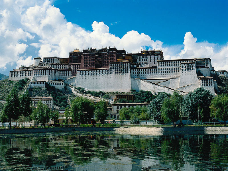 Upon entering the East Portal, visitors will come into the Deyang Shar courtyard where Dalai Lamas watched Tibetan opera. West of the courtyard is the White Palace. As the winter palace of Dalai Lamas, the White Palace is a seven-floor building originally built in 1645. The wall of the palace was painted to white to convey peace and quiet. The Great East Hall on the fourth floor is the largest hall in White Palace, occupying a space of 717 sq meters (about 7,718 sq ft). This hall was also the site for holding momentous religious and political events. The living quarters and offices of regents are on the fifth and sixth floors and while the top floor consists of the East Chamber of Sunshine and the West Chamber of Sunshine. Because of the sunshine in the chambers all year round, the East and West Chamber were the places where Dalai Lamas lived, worked and studied. The furnishings are sumptuousness and comfortable, revealing the dignity of Dalai Lamas. Standing on the spacious balcony, visitors can look down on beautiful Lhasa.